
Vielen Dank für die Unterstützung dieser Website ❤️
Spenden
Spenden
Topografische Karte Parroquia Capital Antonio Rómulo Costa
Klicken Sie auf die Karte, um die Höhe anzuzeigen.
Vielen Dank für die Unterstützung dieser Website ❤️
Spenden
Spenden
Über diese Karte
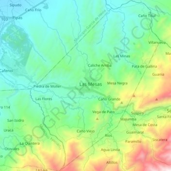
Name: Topografische Karte Parroquia Capital Antonio Rómulo Costa, Höhe, Relief.
Durchschnittliche Höhe: 571 m
Minimale Höhe: 89 m
Maximale Höhe: 2.010 m
Vielen Dank für die Unterstützung dieser Website ❤️
Spenden
Spenden