
Topografische Karte Mayiladuthurai
Klicken Sie auf die Karte, um die Höhe anzuzeigen.
Mayiladuthurai
Mayliladuthurai is situated at a distance of 281 kilometres (175 mi) from Chennai and 122 kilometres (76 mi) from Tiruchirappalli. The town is located at 11°06′N 79°39′E / 11.10°N 79.65°E / 11.10; 79.65. Situated at a distance of 24 kilometres (15 mi) from the Bay of Bengal coast, the town is situated at an altitude of barely 10 metres (33 ft) above mean sea level. The Kaveri River runs through the town bisecting it into Uttara Mayuram and Mayuram proper. Most of the town lies to the south of the river and the Mayuranathaswami Temple lies a mile to its south. The famous Parimala Ranganatha Perumal temple is situated at Tiruindalur, which lies North of Cauvery river. There is a bathing ghat on the Cauvery river. Agriculture is the most widely practised occupation.
Über diese Karte
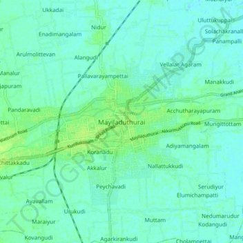
Name: Topografische Karte Mayiladuthurai, Höhe, Relief.
Ort: Mayiladuthurai, Tamil Nadu, 609129, India (11.06186 79.61032 11.14186 79.69032)
Durchschnittliche Höhe: 10 m
Minimale Höhe: 6 m
Maximale Höhe: 18 m
Andere topografische Karten
Klicken Sie auf eine Karte, um ihre Topografie, ihre Höhe und ihr Relief anzuzeigen.