
Spenden
Topografische Karte Campo Largo
Klicken Sie auf die Karte, um die Höhe anzuzeigen.
Spenden
Über diese Karte
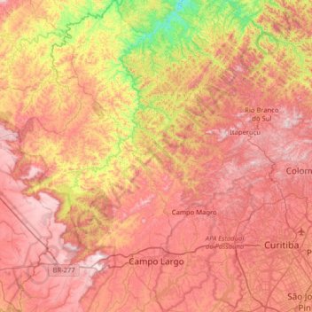
Name: Topografische Karte Campo Largo, Höhe, Relief.
Durchschnittliche Höhe: 852 m
Minimale Höhe: 382 m
Maximale Höhe: 1.232 m
Spenden
Andere topografische Karten
Klicken Sie auf eine Karte, um ihre Topografie, ihre Höhe und ihr Relief anzuzeigen.
Curitiba
Brazil > Paraná > Região Metropolitana de Curitiba
The city covers 432.17 km2 (166.86 sq mi) on the First Plateau of Paraná. Curitiba has a topography of smooth, rounded hills, giving it a relatively regular shape. The city has an average altitude of 934.6 m (3,066 ft) above sea level. The highest point is to the north at 1,021 m (3,350 ft), and with lower…
Durchschnittliche Höhe: 931 m
Bosque Gutierrez
Brazil > Paraná > Região Metropolitana de Curitiba > Curitiba
Durchschnittliche Höhe: 940 m
Curitiba
Brazil > Paraná > Região Metropolitana de Curitiba
The city covers 432.17 km2 (166.86 sq mi) on the First Plateau of Paraná. Curitiba has a topography of smooth, rounded hills, giving it a relatively regular shape. The city has an average altitude of 934.6 m (3,066 ft) above sea level. The highest point is to the north at 1,021 m (3,350 ft), and with lower…
Durchschnittliche Höhe: 931 m
Southern carcara
Brazil > Paraná > Região Metropolitana de Curitiba > Curitiba
Durchschnittliche Höhe: 879 m
Spenden
Curitiba
Brazil > Paraná > Região Metropolitana de Curitiba
The city covers 432.17 km2 (166.86 sq mi) on the First Plateau of Paraná. Curitiba has a topography of smooth, rounded hills, giving it a relatively regular shape. The city has an average altitude of 934.6 m (3,066 ft) above sea level. The highest point is to the north at 1,021 m (3,350 ft), and with lower…
Durchschnittliche Höhe: 931 m
Tijucas do Sul
Brazil > Paraná > Região Metropolitana de Curitiba > Tijucas do Sul > Tijucas do Sul
Durchschnittliche Höhe: 913 m