
Spenden
Topografische Karte Baptiste Lake
Klicken Sie auf die Karte, um die Höhe anzuzeigen.
Spenden
Über diese Karte
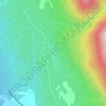
Name: Topografische Karte Baptiste Lake, Höhe, Relief.
Durchschnittliche Höhe: 1.067 m
Minimale Höhe: 823 m
Maximale Höhe: 1.659 m
Spenden
Andere topografische Karten
Klicken Sie auf eine Karte, um ihre Topografie, ihre Höhe und ihr Relief anzuzeigen.
Spillimacheen
Canada > British Columbia > Regional District of East Kootenay > Area G (Forster Creek/Mount Assiniboine)
Durchschnittliche Höhe: 971 m
The Nublet
Canada > British Columbia > Regional District of East Kootenay > Area G (Forster Creek/Mount Assiniboine)
Durchschnittliche Höhe: 2.301 m
Tumbling NE5
Canada > British Columbia > Regional District of East Kootenay > Area G (Forster Creek/Mount Assiniboine)
Durchschnittliche Höhe: 2.146 m
The Bugaboos
Canada > British Columbia > Regional District of East Kootenay > Area G (Forster Creek/Mount Assiniboine)
Durchschnittliche Höhe: 2.412 m
Spenden
Purcell Mountains
Canada > British Columbia > Regional District of East Kootenay > Area G (Forster Creek/Mount Assiniboine)
Durchschnittliche Höhe: 2.710 m
Mount Farnham
Canada > British Columbia > Regional District of East Kootenay > Area G (Forster Creek/Mount Assiniboine)
Durchschnittliche Höhe: 2.791 m
Purcell Mountains
Canada > British Columbia > Regional District of East Kootenay > Area G (Forster Creek/Mount Assiniboine)
Durchschnittliche Höhe: 2.710 m
Mount Allen
Canada > British Columbia > Regional District of East Kootenay > Area G (Forster Creek/Mount Assiniboine)
Durchschnittliche Höhe: 2.674 m
Spenden
Wilmer
Canada > British Columbia > Regional District of East Kootenay > Area G (Forster Creek/Mount Assiniboine)
Durchschnittliche Höhe: 881 m