
Topografische Karte Taiyuan
Interaktive Karte
Klicken Sie auf die Karte, um die Höhe anzuzeigen.
Über diese Karte
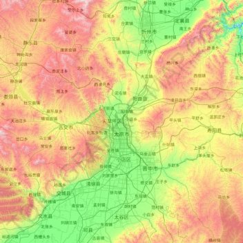
Name: Topografische Karte Taiyuan, Höhe, Relief.
Ort: Taiyuan, Shanxi, China (37.44142 111.50892 38.42085 113.14779)
Durchschnittliche Höhe: 1.195 m
Minimale Höhe: 550 m
Maximale Höhe: 2.376 m
Taiyuan experiences a cold semi-arid climate (Köppen climate classification BSk). Taiyuan has a temperate monsoon climate.Spring is dry, with occasional dust storms, followed by early summer heat waves. Summer tends to be warm to hot with most of the year's rainfall concentrated in July and August. Winter is long and cold, but dry and sunny. Because of the aridity, there tends to be considerable diurnal variation in temperature, except during the summer. The weather is much cooler than comparable-latitude cities, such as Shijiazhuang, due to the moderately high altitude. The monthly 24-hour average temperature range from −5.0 °C (23.0 °F) in January to 24.0 °C (75.2 °F) in July, while the annual mean is 10.42 °C (50.8 °F). With monthly percent possible sunshine ranging from 51 percent in July to 61 percent in May, there are 2,502 hours of sunshine annually.
Andere topografische Karten
Klicken Sie auf eine Karte, um ihre Topografie, ihre Höhe und ihr Relief anzuzeigen.
Tianzhen County
Tianzhen County, Datong, Shanxi, 038200, China
Durchschnittliche Höhe: 1.239 m
Lecture Hall
Lecture Hall, Dongcheng Subdistrict, Yuncheng, Yanhu District, Yuncheng, Shanxi, 044031, China
Durchschnittliche Höhe: 368 m
Yungang District
Yungang District, Datong, Shanxi, 037001, China
Durchschnittliche Höhe: 1.186 m
Gaojiazhuang
Gaojiazhuang, Shuocheng District, Shuozhou City, Shanxi, China
Durchschnittliche Höhe: 1.183 m
Lingqiu County
Lingqiu County, Datong, Shanxi, China
Durchschnittliche Höhe: 1.250 m
Guangling County
China > Shanxi > Datong City
Guangling County, Datong City, Shanxi, China
Durchschnittliche Höhe: 1.424 m
后赵家庄村
China > Shanxi > Chengbei Subdistrict
后赵家庄村, Chengbei Subdistrict, Lishi District, Lüliang City, Shanxi, China
Durchschnittliche Höhe: 1.007 m
Changzhi
China > Shanxi > Changzhi > Yingxiongnanlu Subdistrict
Changzhi, Yingxiongnanlu Subdistrict, Luzhou District, Changzhi City, Shanxi, 046099, China
Durchschnittliche Höhe: 986 m
Xing County
China > Shanxi > Xing County
Xing County, Lüliang City, Shanxi, China
Durchschnittliche Höhe: 1.246 m
Taigu County
China > Shanxi > Taigu County > Jinzhong City
Taigu County, Jinzhong City, Shanxi, China
Durchschnittliche Höhe: 1.098 m
Linyi
China > Shanxi > Linyi County
Linyi, Linyi County, Yuncheng City, Shanxi, China
Durchschnittliche Höhe: 455 m
Linfen
China > Shanxi > Linfen > Jiefanglu Subdistrict
Linfen, Jiefanglu Subdistrict, Yaodu District, Linfen City, Shanxi, 041000, China
Durchschnittliche Höhe: 582 m
Linyi County
Linyi County, Yuncheng City, Shanxi, 044100, China
Durchschnittliche Höhe: 464 m
Pingcheng District
China > Shanxi > Pingcheng District
Datong, Pingcheng District, Datong City, Shanxi, 037004, China
Durchschnittliche Höhe: 1.149 m