Geolokalisieren
👉 Easily get elevation data in JSON, GeoTIFF and KML formats using Elevation API
Vielen Dank für die Unterstützung dieser Website ❤️
Spenden

Topografische Karte Ignacio

Klicken Sie auf die Karte, um die Höhe anzuzeigen.

👉 Easily get elevation data in JSON, GeoTIFF and KML formats using Elevation API
Vielen Dank für die Unterstützung dieser Website ❤️
Spenden

Über diese Karte

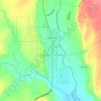
Name: Topografische Karte Ignacio, Höhe, Relief.

Ort: Ignacio, La Plata County, Colorado, 81137, United States (37.10707 -107.64539 37.12534 -107.63014)

Durchschnittliche Höhe: 1.984 m

Minimale Höhe: 1.954 m

Maximale Höhe: 2.026 m

👉 Easily get elevation data in JSON, GeoTIFF and KML formats using Elevation API
Vielen Dank für die Unterstützung dieser Website ❤️
Spenden

Andere topografische Karten

Klicken Sie auf eine Karte, um ihre Topografie, ihre Höhe und ihr Relief anzuzeigen.

Durango

United States > Colorado > La Plata County > Durango

Durango is located at 37°16′N 107°52′W / 37.267°N 107.867°W / 37.267; -107.867 at an elevation of 6,512 ft (1,988 m). At the 2020 United States Census, the town had a total area of 10,946 acres (44.296 km2) including 1,533 acres (6.203 km2) of water.

Durchschnittliche Höhe: 2.360 m

Redmesa

United States > Colorado > La Plata County

Durchschnittliche Höhe: 1.987 m

Cherry Creek

United States > Colorado > La Plata County

Durchschnittliche Höhe: 2.427 m

Vielen Dank für die Unterstützung dieser Website ❤️
Spenden

Missionary Ridge

United States > Colorado > La Plata County

Durchschnittliche Höhe: 3.001 m

Twin Buttes

United States > Colorado > La Plata County > Durango

Durchschnittliche Höhe: 2.209 m

Cherry Creek

United States > Colorado > La Plata County

Durchschnittliche Höhe: 2.205 m

Texas Creek

United States > Colorado > La Plata County > Columbus

Durchschnittliche Höhe: 2.299 m

Vielen Dank für die Unterstützung dieser Website ❤️
Spenden

Grimes Creek

United States > Colorado > La Plata County

Durchschnittliche Höhe: 2.718 m