
Vielen Dank für die Unterstützung dieser Website ❤️
Spenden
Spenden
Topografische Karte Sonamarg
Klicken Sie auf die Karte, um die Höhe anzuzeigen.
Vielen Dank für die Unterstützung dieser Website ❤️
Spenden
Spenden
Sonamarg
The hill station is situated in the Kashmir Valley, at an altitude of 2,730 metres (8,960 ft) Combined with the alpine meadows that bloom in the summer as well as rivers and lakes stocked with fish, Sonamarg is a notable tourist destination in Jammu and Kashmir.
Vielen Dank für die Unterstützung dieser Website ❤️
Spenden
Spenden
Über diese Karte
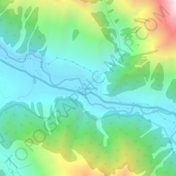
Name: Topografische Karte Sonamarg, Höhe, Relief.
Ort: Sonamarg, Kangan, Ganderbal, Jammu and Kashmir, India (34.28239 75.27656 34.32239 75.31656)
Durchschnittliche Höhe: 3.068 m
Minimale Höhe: 2.639 m
Maximale Höhe: 4.240 m
Vielen Dank für die Unterstützung dieser Website ❤️
Spenden
Spenden