
Topografische Karte El Centro
Interaktive Karte
Klicken Sie auf die Karte, um die Höhe anzuzeigen.
Über diese Karte
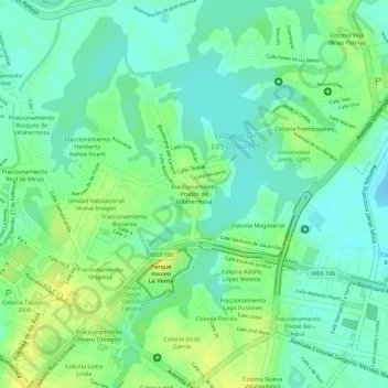
Name: Topografische Karte El Centro, Höhe, Relief.
Ort: El Centro, Villahermosa, Centro, Tabasco, México (18.00538 -92.93377 18.00621 -92.93294)
Durchschnittliche Höhe: 12 m
Minimale Höhe: 2 m
Maximale Höhe: 23 m
Andere topografische Karten
Klicken Sie auf eine Karte, um ihre Topografie, ihre Höhe und ihr Relief anzuzeigen.
Parque Principal Tierra Colorada
México > Tabasco > Villahermosa
Parque Principal Tierra Colorada, Villahermosa, Centro, Tabasco, México
Durchschnittliche Höhe: 9 m
Parque Indeco
México > Tabasco > Villahermosa
Parque Indeco, Villahermosa, Centro, Tabasco, México
Durchschnittliche Höhe: 7 m
Parque Laguna Encantada
México > Tabasco > Villahermosa
Parque Laguna Encantada, Villahermosa, Centro, Tabasco, México
Durchschnittliche Höhe: 8 m
Parque Morelos
México > Tabasco > Villahermosa
Parque Morelos, Villahermosa, Centro, Tabasco, México
Durchschnittliche Höhe: 12 m