
Topografische Karte Slaithwaite
Klicken Sie auf die Karte, um die Höhe anzuzeigen.
Slaithwaite
In the 1848 edition of 'A Topographical Dictionary of England', Samuel Lewis (the editor) wrote:- "the lands are in meadow and pasture, with a small portion of arable; the scenery is bold and romantic. In the quarries of the district are found vegetable fossils, especially firs and other mountain trees. The village is beautifully seated in the valley of the river Colne; the inhabitants are chiefly employed in the woollen manufacture, in the spinning of cotton and silk, and in silk-weaving"
Über diese Karte
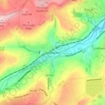
Name: Topografische Karte Slaithwaite, Höhe, Relief.
Durchschnittliche Höhe: 241 m
Minimale Höhe: 107 m
Maximale Höhe: 391 m
Andere topografische Karten
Klicken Sie auf eine Karte, um ihre Topografie, ihre Höhe und ihr Relief anzuzeigen.
Huddersfield Broad Canal
United Kingdom > England > Kirklees > Huddersfield
Durchschnittliche Höhe: 97 m
Storthes Hall Park Campus
United Kingdom > England > Kirklees > Kirkburton
Durchschnittliche Höhe: 173 m