
Topografische Karte Los Alamos
Interaktive Karte
Klicken Sie auf die Karte, um die Höhe anzuzeigen.
Über diese Karte
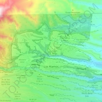
Name: Topografische Karte Los Alamos, Höhe, Relief.
Durchschnittliche Höhe: 2.196 m
Minimale Höhe: 1.990 m
Maximale Höhe: 2.638 m
Los Alamos is located in northern New Mexico between the Rio Grande and the eastern rim of the Valles Caldera on the Pajarito Plateau, approximately 35 mi (56 km) to the northwest of Santa Fe. The elevation at the post office is 7,320 feet (2,230 m) and total land area is 11.14 square miles (28.9 km2).
Andere topografische Karten
Klicken Sie auf eine Karte, um ihre Topografie, ihre Höhe und ihr Relief anzuzeigen.
Los Alamos
United States > New Mexico > Los Alamos County > Los Alamos
Los Alamos, Los Alamos County, New Mexico, 87544, United States
Durchschnittliche Höhe: 2.196 m