
Spenden
Topografische Karte Silent Pass
Klicken Sie auf die Karte, um die Höhe anzuzeigen.
Spenden
Über diese Karte
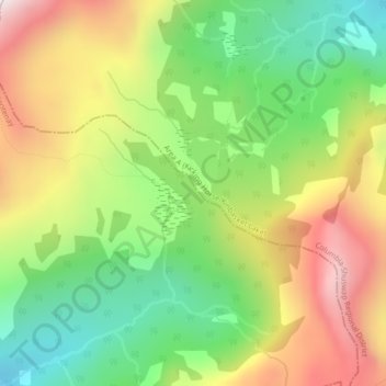
Name: Topografische Karte Silent Pass, Höhe, Relief.
Durchschnittliche Höhe: 2.100 m
Minimale Höhe: 1.745 m
Maximale Höhe: 2.546 m
Spenden
Andere topografische Karten
Klicken Sie auf eine Karte, um ihre Topografie, ihre Höhe und ihr Relief anzuzeigen.
Cooper Creek
Canada > British Columbia > Regional District of Central Kootenay > Area D (Lardeau Valley/Duncan Lake)
Durchschnittliche Höhe: 1.573 m
Keen Creek
Canada > British Columbia > Regional District of Central Kootenay > Area D (Lardeau Valley/Duncan Lake)
Durchschnittliche Höhe: 976 m
Poplar Creek
Canada > British Columbia > Regional District of Central Kootenay > Area D (Lardeau Valley/Duncan Lake)
Durchschnittliche Höhe: 1.732 m
Duncan Lake
Canada > British Columbia > Regional District of Central Kootenay > Area D (Lardeau Valley/Duncan Lake)
Durchschnittliche Höhe: 1.658 m
Spenden
Butters Lake
Canada > British Columbia > Regional District of Central Kootenay > Area D (Lardeau Valley/Duncan Lake)
Durchschnittliche Höhe: 2.133 m
Kootenay Lake Provincial Park - Coffee Creek Site
Canada > British Columbia > Regional District of Central Kootenay > Area D (Lardeau Valley/Duncan Lake)
Durchschnittliche Höhe: 700 m