
Topografische Karte Espanola
Interaktive Karte
Klicken Sie auf die Karte, um die Höhe anzuzeigen.
Über diese Karte
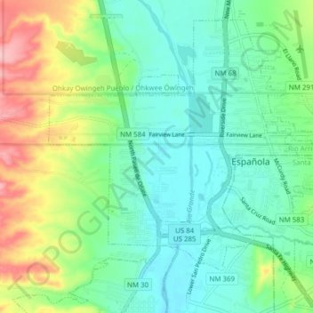
Name: Topografische Karte Espanola, Höhe, Relief.
Ort: Espanola, Santa Fe County, New Mexico, United States (35.97629 -106.10767 36.03103 -106.03065)
Durchschnittliche Höhe: 1.739 m
Minimale Höhe: 1.697 m
Maximale Höhe: 1.839 m
Española lies at an elevation of around 5,595 feet (1,705 m) with much variance. It is in a valley nestled between the Jemez and Sangre de Cristo mountain ranges, and the meeting point of three rivers, the Rio Grande, the Rio Chama, and the Rio Santa Cruz.
Andere topografische Karten
Klicken Sie auf eine Karte, um ihre Topografie, ihre Höhe und ihr Relief anzuzeigen.
Santa Fe
United States > New Mexico > Santa Fe County
Santa Fe, Santa Fe County, New Mexico, United States
Durchschnittliche Höhe: 2.221 m
Los Cerrillos
United States > New Mexico > Santa Fe County
Los Cerrillos, Santa Fe County, New Mexico, United States
Durchschnittliche Höhe: 1.757 m
Tesuque Pueblo
United States > New Mexico > Santa Fe County
Tesuque Pueblo, Santa Fe County, New Mexico, United States
Durchschnittliche Höhe: 1.971 m
Eldorado at Santa Fe
United States > New Mexico > Santa Fe County
Eldorado at Santa Fe, Santa Fe County, New Mexico, United States
Durchschnittliche Höhe: 2.036 m
Edgewood
United States > New Mexico > Santa Fe County
Edgewood, Santa Fe County, New Mexico, 87015, United States
Durchschnittliche Höhe: 2.029 m
Eldorado at Santa Fe
United States > New Mexico > Santa Fe County
Eldorado at Santa Fe, Santa Fe County, New Mexico, United States
Durchschnittliche Höhe: 2.036 m
La Puebla
United States > New Mexico > Santa Fe County
La Puebla, Santa Fe County, New Mexico, United States
Durchschnittliche Höhe: 1.805 m
Rancho Viejo
United States > New Mexico > Santa Fe County > Rancho Viejo
Rancho Viejo, Santa Fe County, New Mexico, 87508, United States
Durchschnittliche Höhe: 1.979 m