Geolokalisieren
👉 Easily get elevation data in JSON, GeoTIFF and KML formats using Elevation API
Vielen Dank für die Unterstützung dieser Website ❤️
Spenden

Topografische Karte Sacey

Klicken Sie auf die Karte, um die Höhe anzuzeigen.

👉 Easily get elevation data in JSON, GeoTIFF and KML formats using Elevation API
Vielen Dank für die Unterstützung dieser Website ❤️
Spenden

Sacey

Plusieurs études ont été menées afin de caractériser les types climatiques auxquels est exposé le territoire national. Les zonages obtenus diffèrent selon les méthodes utilisées, la nature et le nombre des paramètres pris en compte, le maillage territorial des données et la période de référence. En 2010, le climat de la commune était ainsi de type climat océanique franc, selon une étude du Centre national de la recherche scientifique (CNRS) s'appuyant sur une méthode combinant données climatiques et facteurs de milieu (topographie, occupation des sols, etc.) et des données couvrant la période 1971-2000. En 2020, le climat prédominant est classé Cfb, selon la classification de Köppen-Geiger, pour la période 1988-2017, à savoir un climat tempéré à été frais sans saison sèche. Par ailleurs Météo-France publie en 2020 une nouvelle typologie des climats de la France métropolitaine dans laquelle la commune est exposée à un climat océanique et est dans la région climatique Bretagne orientale et méridionale, Pays nantais, Vendée, caractérisée par une faible pluviométrie en été et une bonne insolation. Elle est en outre dans la zone H2a au titre de la réglementation environnementale 2020 des constructions neuves.

Wikipedia (CC-BY-SA 3.0)

👉 Easily get elevation data in JSON, GeoTIFF and KML formats using Elevation API
Vielen Dank für die Unterstützung dieser Website ❤️
Spenden

Über diese Karte

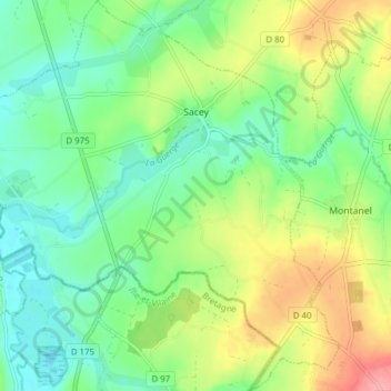
Name: Topografische Karte Sacey, Höhe, Relief.

Ort: Sacey, Avranches, Manche, Normandie, France métropolitaine, 50170, France (48.47212 -1.49592 48.52339 -1.42296)

Durchschnittliche Höhe: 37 m

Minimale Höhe: 3 m

Maximale Höhe: 98 m

👉 Easily get elevation data in JSON, GeoTIFF and KML formats using Elevation API
Vielen Dank für die Unterstützung dieser Website ❤️
Spenden

Andere topografische Karten

Klicken Sie auf eine Karte, um ihre Topografie, ihre Höhe und ihr Relief anzuzeigen.

Les Câbles

France > Normandie > Manche > Cherbourg-en-Cotentin

Durchschnittliche Höhe: 121 m

Le Hameau au Gendre

France > Normandie > Manche > Tourneville-sur-Mer > Annoville

Durchschnittliche Höhe: 17 m

Le Champ Long

France > Normandie > Manche > Sacey

Durchschnittliche Höhe: 36 m

Atré

France > Normandie > Manche > Saint-James

Durchschnittliche Höhe: 126 m

Vielen Dank für die Unterstützung dieser Website ❤️
Spenden

La Roulandière

France > Normandie > Manche > Cerisy-la-Salle

Durchschnittliche Höhe: 117 m

Les Roches

France > Normandie > Manche > Montfarville

Durchschnittliche Höhe: 9 m

La Cailletterie

France > Normandie > Manche > Anneville-en-Saire

Durchschnittliche Höhe: 27 m

Le Perron

France > Normandie > Manche > Crasville

Durchschnittliche Höhe: 53 m

Vielen Dank für die Unterstützung dieser Website ❤️
Spenden

Hameau aux Mières

France > Normandie > Manche > La Hague > Omonville-la-Petite

Durchschnittliche Höhe: 61 m

Le Haut Chemin

France > Normandie > Manche > Prétot-Sainte-Suzanne

Durchschnittliche Höhe: 37 m

La Croix Luce

France > Normandie > Manche > Cherbourg-en-Cotentin

Durchschnittliche Höhe: 111 m

Barneville Plage

France > Normandie > Manche

Durchschnittliche Höhe: 10 m

Vielen Dank für die Unterstützung dieser Website ❤️
Spenden

Armanville

France > Normandie > Manche > Pirou

Durchschnittliche Höhe: 5 m

Carrefour de la Petite Rue

France > Normandie > Manche > Valognes

Durchschnittliche Höhe: 52 m

La Gare

France > Normandie > Manche > Lithaire

Durchschnittliche Höhe: 60 m

La Maison Vard

France > Normandie > Manche > Saint-Sauveur-Villages > Vaudrimesnil

Durchschnittliche Höhe: 36 m

Vielen Dank für die Unterstützung dieser Website ❤️
Spenden

Cotteley

France > Normandie > Manche > Neufmesnil

Durchschnittliche Höhe: 47 m

Le Tasset

France > Normandie > Manche > Cerisy-la-Salle

Durchschnittliche Höhe: 116 m

Le Rocher du Sard

France > Normandie > Manche > Carolles

Durchschnittliche Höhe: 25 m

Launay

France > Normandie > Manche > Reffuveille

Durchschnittliche Höhe: 192 m

Vielen Dank für die Unterstützung dieser Website ❤️
Spenden

Saint-Denis

France > Normandie > Manche > Montjoie-Saint-Martin

Durchschnittliche Höhe: 138 m

La Grande Tapinière

France > Normandie > Manche > Hudimesnil

Durchschnittliche Höhe: 64 m

Le Bois

France > Normandie > Manche > Vezins

Durchschnittliche Höhe: 97 m

Village Talfaret

France > Normandie > Manche > Couville

Durchschnittliche Höhe: 94 m

Vielen Dank für die Unterstützung dieser Website ❤️
Spenden

Les Plains

France > Normandie > Manche > Saint-Sébastien-de-Raids

Durchschnittliche Höhe: 17 m

Longuerac

France > Normandie > Manche > Les Moitiers-en-Bauptois

Durchschnittliche Höhe: 14 m

Le Mehenry

France > Normandie > Manche > Saint-Senier-sous-Avranches

Durchschnittliche Höhe: 66 m

Le Quesnay de Bas

France > Normandie > Manche > Saint-André-de-Bohon

Durchschnittliche Höhe: 8 m

Vielen Dank für die Unterstützung dieser Website ❤️
Spenden

La Brocqueterie

France > Normandie > Manche > Gouville-sur-Mer

Durchschnittliche Höhe: 12 m

Le Val

France > Normandie > Manche > Tourville-sur-Sienne

Durchschnittliche Höhe: 29 m

La Victoire

France > Normandie > Manche > Valognes

Durchschnittliche Höhe: 41 m

Caugé

France > Normandie > Manche > Pontorson

Durchschnittliche Höhe: 16 m

Vielen Dank für die Unterstützung dieser Website ❤️
Spenden

La Forge Fallot

France > Normandie > Manche > Airel

Durchschnittliche Höhe: 20 m

Les Cloutiers

France > Normandie > Manche > Saint-Nicolas-de-Pierrepont

Durchschnittliche Höhe: 36 m

Les Troix Croix

France > Normandie > Manche > Saint-Pair-sur-Mer

Durchschnittliche Höhe: 27 m

Hameau Jourdan

France > Normandie > Manche > La Hague > Vasteville

Durchschnittliche Höhe: 103 m

Vielen Dank für die Unterstützung dieser Website ❤️
Spenden

Tombelaine

France > Normandie > Manche > Genêts

Durchschnittliche Höhe: 0 m

Hau de la Lande

France > Normandie > Manche > Varouville

Durchschnittliche Höhe: 54 m

La Sorière

France > Normandie > Manche > Montsurvent

Durchschnittliche Höhe: 51 m

Le Mesnil Grimault

France > Normandie > Manche > Condé-sur-Vire

Durchschnittliche Höhe: 69 m

Vielen Dank für die Unterstützung dieser Website ❤️
Spenden

Hameau Labour

France > Normandie > Manche > Tourneville-sur-Mer > Lingreville

Durchschnittliche Höhe: 24 m

Malassis

France > Normandie > Manche > Bricquebec-en-Cotentin > Le Vrétot

Durchschnittliche Höhe: 59 m

Montessy

France > Normandie > Manche > Picauville

Durchschnittliche Höhe: 11 m

Rose

France > Normandie > Manche > Saint-Maurice-en-Cotentin

Durchschnittliche Höhe: 64 m

Vielen Dank für die Unterstützung dieser Website ❤️
Spenden

Le Repos

France > Normandie > Manche > Huisnes-sur-Mer

Durchschnittliche Höhe: 15 m

La Poissonnière

France > Normandie > Manche > Les Biards

Durchschnittliche Höhe: 108 m

Hameau Tourraine

France > Normandie > Manche > Saussemesnil

Durchschnittliche Höhe: 109 m

La Gaslonde

France > Normandie > Manche > Lessay

Durchschnittliche Höhe: 14 m

Vielen Dank für die Unterstützung dieser Website ❤️
Spenden

Le Moulin à Vent

France > Normandie > Manche > Créances

Durchschnittliche Höhe: 14 m

L'Hôtel au Boscq

France > Normandie > Manche > Geffosses

Durchschnittliche Höhe: 20 m

Drôme

France > Normandie > Manche > Saint-Vigor-des-Monts

Durchschnittliche Höhe: 97 m

La Petite Paumerie

France > Normandie > Manche > Agneaux

Durchschnittliche Höhe: 64 m

Vielen Dank für die Unterstützung dieser Website ❤️
Spenden

Les Rues

France > Normandie > Manche > Le Vast

Durchschnittliche Höhe: 77 m

Les Martins

France > Normandie > Manche > Tollevast

Durchschnittliche Höhe: 129 m

Le Pavement

France > Normandie > Manche > Le Homméel

Durchschnittliche Höhe: 92 m

Vielen Dank für die Unterstützung dieser Website ❤️
Spenden

Le Gué

France > Normandie > Manche > Saint-Martin-le-Bouillant

Durchschnittliche Höhe: 184 m

Village au Clair

France > Normandie > Manche > Besneville

Durchschnittliche Höhe: 49 m

Le Noyer

France > Normandie > Manche > Saint-Planchers

Durchschnittliche Höhe: 46 m

La Pouerie

France > Normandie > Manche > Cerisy-la-Forêt

Durchschnittliche Höhe: 106 m

Vielen Dank für die Unterstützung dieser Website ❤️
Spenden

Le Hable

France > Normandie > Manche > Regnéville-sur-Mer

Durchschnittliche Höhe: 13 m

Le Mesnil-Hue

France > Normandie > Manche > Gavray-sur-Sienne

Durchschnittliche Höhe: 135 m

Hameau Carpentier

France > Normandie > Manche > Brix

Durchschnittliche Höhe: 90 m

Village aux Gras

France > Normandie > Manche > Boisroger

Durchschnittliche Höhe: 38 m

Vielen Dank für die Unterstützung dieser Website ❤️
Spenden

La Coudraye

France > Normandie > Manche > Percy-en-Normandie > Le Chefresne

Durchschnittliche Höhe: 184 m

La Filature

France > Normandie > Manche > Teurthéville-Hague

Durchschnittliche Höhe: 71 m

L'Orphelinat

France > Normandie > Manche > Tamerville

Durchschnittliche Höhe: 63 m

Le Pont de Monceaux

France > Normandie > Manche > Contrières

Durchschnittliche Höhe: 35 m

Vielen Dank für die Unterstützung dieser Website ❤️
Spenden

La Pouchinière

France > Normandie > Manche > Quibou

Durchschnittliche Höhe: 84 m

Hameau Terrier

France > Normandie > Manche > Brix

Durchschnittliche Höhe: 98 m

Durécu

France > Normandie > Manche > Pierreville

Durchschnittliche Höhe: 52 m

La Roque Jaune

France > Normandie > Manche > Réville

Durchschnittliche Höhe: 1 m

Vielen Dank für die Unterstützung dieser Website ❤️
Spenden

Village de l'Église

France > Normandie > Manche > Gonfreville

Durchschnittliche Höhe: 15 m

Les Masses

France > Normandie > Manche > Morsalines

Durchschnittliche Höhe: 46 m

Hameau Rabusquet

France > Normandie > Manche > Rufosses

Durchschnittliche Höhe: 110 m

La Perdrière

France > Normandie > Manche > Anctoville-sur-Boscq

Durchschnittliche Höhe: 54 m

Vielen Dank für die Unterstützung dieser Website ❤️
Spenden

Hameau de Bas

France > Normandie > Manche > Barneville Plage

Durchschnittliche Höhe: 20 m

Le Ligue

France > Normandie > Manche > Rauville-la-Place

Durchschnittliche Höhe: 20 m

Les Acacias

France > Normandie > Manche > Port-Bail-sur-Mer > Portbail

Durchschnittliche Höhe: 6 m

Bouillon

France > Normandie > Manche > Jullouville

Durchschnittliche Höhe: 46 m

Vielen Dank für die Unterstützung dieser Website ❤️
Spenden

La Championnière

France > Normandie > Manche > Jullouville

Durchschnittliche Höhe: 46 m

La Chevalerie

France > Normandie > Manche > Marigny-Le-Lozon > Marigny

Durchschnittliche Höhe: 86 m

Ardevon

France > Normandie > Manche

Durchschnittliche Höhe: 17 m

Le Pontois

France > Normandie > Manche > Bricqueville-sur-Mer

Durchschnittliche Höhe: 35 m

Vielen Dank für die Unterstützung dieser Website ❤️
Spenden

Le Buisson

France > Normandie > Manche > Créances

Durchschnittliche Höhe: 25 m

Le Village Pacary

France > Normandie > Manche > Raids

Durchschnittliche Höhe: 14 m

Cartot

France > Normandie > Manche > Lessay

Durchschnittliche Höhe: 23 m

La Chapelle-du-Fest

France > Normandie > Manche > Saint-Amand-Villages

Durchschnittliche Höhe: 106 m

Vielen Dank für die Unterstützung dieser Website ❤️
Spenden

Le Village Sauvage

France > Normandie > Manche > Bréhal

Durchschnittliche Höhe: 29 m

La Pérelle

France > Normandie > Manche > La Meauffe

Durchschnittliche Höhe: 40 m

La Perrelle

France > Normandie > Manche > Couville

Durchschnittliche Höhe: 93 m

Vielen Dank für die Unterstützung dieser Website ❤️
Spenden

Le Breuil

France > Normandie > Manche > Bricqueville-la-Blouette

Durchschnittliche Höhe: 61 m

La Forge

France > Normandie > Manche > Avranches > Saint-Martin-des-Champs

Durchschnittliche Höhe: 79 m

Le Croissant

France > Normandie > Manche > Saint-Pair-sur-Mer

Durchschnittliche Höhe: 37 m

Les Cardets

France > Normandie > Manche > Amfreville

Durchschnittliche Höhe: 15 m

Vielen Dank für die Unterstützung dieser Website ❤️
Spenden

Hattainville

France > Normandie > Manche

Durchschnittliche Höhe: 41 m

La Guesnonnière

France > Normandie > Manche > Les Cresnays

Durchschnittliche Höhe: 134 m

Le Vieux Bourg

France > Normandie > Manche > Brécey

Durchschnittliche Höhe: 65 m

Vielen Dank für die Unterstützung dieser Website ❤️
Spenden