
Topografische Karte Tarn Hows
Klicken Sie auf die Karte, um die Höhe anzuzeigen.
Über diese Karte
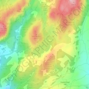
Name: Topografische Karte Tarn Hows, Höhe, Relief.
Durchschnittliche Höhe: 187 m
Minimale Höhe: 74 m
Maximale Höhe: 315 m
Andere topografische Karten
Klicken Sie auf eine Karte, um ihre Topografie, ihre Höhe und ihr Relief anzuzeigen.
Levers Water
United Kingdom > England > Westmorland and Furness > Coniston
Durchschnittliche Höhe: 517 m
Old Man of Coniston
United Kingdom > England > Westmorland and Furness > Coniston
The first section rising steeply from Coniston is a metalled road, maintained partly to provide access to the quarry. This leads to a car park at an altitude of 740 ft (230 m), a popular starting point for climbs. Beyond here motor vehicles are prohibited, but the track continues to its summit at 2,000 ft (610…
Durchschnittliche Höhe: 501 m
Goats Water
United Kingdom > England > Westmorland and Furness > Coniston
Durchschnittliche Höhe: 533 m
Yew Tree Tarn
United Kingdom > England > Westmorland and Furness > Coniston
Durchschnittliche Höhe: 186 m
Glassy Crag
United Kingdom > England > Westmorland and Furness > Coniston
Durchschnittliche Höhe: 431 m