
Topografische Karte Salcedo
Klicken Sie auf die Karte, um die Höhe anzuzeigen.
Über diese Karte
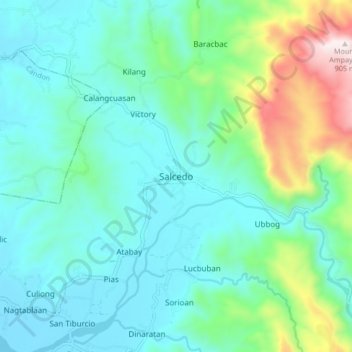
Name: Topografische Karte Salcedo, Höhe, Relief.
Ort: Salcedo, Ilocos Sur, Ilocos Region, Philippines (17.11107 120.49634 17.19107 120.57634)
Durchschnittliche Höhe: 202 m
Minimale Höhe: 15 m
Maximale Höhe: 898 m
Andere topografische Karten
Klicken Sie auf eine Karte, um ihre Topografie, ihre Höhe und ihr Relief anzuzeigen.
Candon
Candon City is situated in the lower central portion of the Province of Ilocos Sur. It has a "C" shape with elevations ranging from 10 – 500 ft above sea level. The city is 346 kilometres (215 mi) from Metro Manila and 61 kilometres (38 mi) from Vigan City, the provincial capital.
Durchschnittliche Höhe: 83 m