
Topografische Karte City of Johannesburg Metropolitan Municipality
Interaktive Karte
Klicken Sie auf die Karte, um die Höhe anzuzeigen.
Über diese Karte
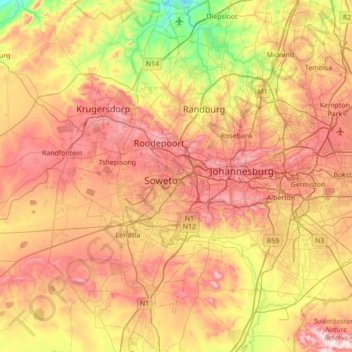
Name: Topografische Karte City of Johannesburg Metropolitan Municipality, Höhe, Relief.
Ort: City of Johannesburg Metropolitan Municipality, Gauteng, RSA (-26.52629 27.71427 -25.90283 28.21446)
Durchschnittliche Höhe: 1.582 m
Minimale Höhe: 1.275 m
Maximale Höhe: 1.909 m
Andere topografische Karten
Klicken Sie auf eine Karte, um ihre Topografie, ihre Höhe und ihr Relief anzuzeigen.
Tshwane Ward 77
Tshwane Ward 77, Pretoria, City of Tshwane Metropolitan Municipality, Gauteng, RSA
Durchschnittliche Höhe: 1.502 m
Johannesburg Ward 26
Johannesburg Ward 26, Soweto, City of Johannesburg Metropolitan Municipality, Gauteng, 1864, RSA
Durchschnittliche Höhe: 1.680 m