
Topografische Karte Gemeinde Kössen
Interaktive Karte
Klicken Sie auf die Karte, um die Höhe anzuzeigen.
Über diese Karte
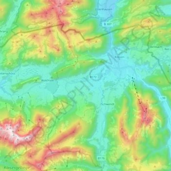
Name: Topografische Karte Gemeinde Kössen, Höhe, Relief.
Ort: Gemeinde Kössen, Bezirk Kitzbühel, Tyrol, 6345, Austria (47.59728 12.31908 47.69638 12.52534)
Durchschnittliche Höhe: 979 m
Minimale Höhe: 562 m
Maximale Höhe: 1.977 m
Kössen's topography lends itself to air sports in the summer months. The surrounding mountain massifs create great thermals, which are near-perfect for hang gliding and paragliding flights, whilst the valley-floor makes safe landing-grounds, as it is broad, flat and mostly meadow-land; furthermore, the winter ski-lifts allow equal access to the summits in their off-season, for the new market of air-sports adventurers.
Andere topografische Karten
Klicken Sie auf eine Karte, um ihre Topografie, ihre Höhe und ihr Relief anzuzeigen.
Schwendt
Schwendt, Bezirk Kitzbühel, 6385, Austria
Durchschnittliche Höhe: 948 m
Scheffau
Austria > Bezirk Kitzbühel > Sankt Johann in Tirol
Scheffau, Sankt Johann in Tirol, Bezirk Kitzbühel, Austria
Durchschnittliche Höhe: 939 m
Mittagskogel
Austria > Bezirk Kitzbühel > Jochberg
Mittagskogel, Jochberg, Bezirk Kitzbühel, Austria
Durchschnittliche Höhe: 1.838 m
Kitzbühel
Kitzbühel, Bezirk Kitzbühel, 6370, Austria
Durchschnittliche Höhe: 1.176 m