Geolokalisieren
👉 Easily get elevation data in JSON, GeoTIFF and KML formats using Elevation API
Vielen Dank für die Unterstützung dieser Website ❤️
Spenden

Topografische Karte Rathdangan

Klicken Sie auf die Karte, um die Höhe anzuzeigen.

👉 Easily get elevation data in JSON, GeoTIFF and KML formats using Elevation API
Vielen Dank für die Unterstützung dieser Website ❤️
Spenden

Rathdangan

Evidence of habitation is shown by a Bronze Age burial cist, a fort dating from at least the eight-century and a Norman moat at Killamoat. A 1668 survey records 18 houses in the village. Due to its mountainous elevation, in the severe winters of 1947, 1963 and 1982, Rathdangan was isolated for weeks. In 1985 the town was caught up in the moving statues phenomena gripping Ireland when people claimed to see the Rathdangan Marian Year Virgin Mary statue move.

Wikipedia (CC-BY-SA 3.0)

👉 Easily get elevation data in JSON, GeoTIFF and KML formats using Elevation API
Vielen Dank für die Unterstützung dieser Website ❤️
Spenden

Über diese Karte

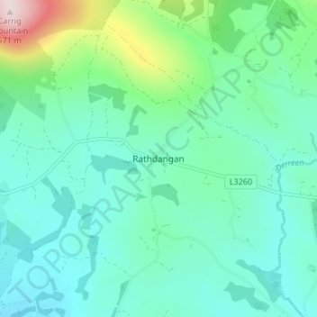
Name: Topografische Karte Rathdangan, Höhe, Relief.

Ort: Rathdangan, The Municipal District of Baltinglass, County Wicklow, Leinster, W91 D273, Ireland (52.89982 -6.56554 52.93982 -6.52554)

Durchschnittliche Höhe: 228 m

Minimale Höhe: 141 m

Maximale Höhe: 570 m

👉 Easily get elevation data in JSON, GeoTIFF and KML formats using Elevation API
Vielen Dank für die Unterstützung dieser Website ❤️
Spenden

Andere topografische Karten

Klicken Sie auf eine Karte, um ihre Topografie, ihre Höhe und ihr Relief anzuzeigen.

Knocksink Wood

Ireland > County Wicklow

Durchschnittliche Höhe: 175 m

Blessington

Ireland > County Wicklow

Durchschnittliche Höhe: 204 m

Bray

Ireland > County Wicklow

Durchschnittliche Höhe: 42 m

Rathdrum

Ireland > County Wicklow

Durchschnittliche Höhe: 136 m

Vielen Dank für die Unterstützung dieser Website ❤️
Spenden

Laragh

Ireland > County Wicklow

Durchschnittliche Höhe: 215 m

Roundwood

Ireland > County Wicklow

Durchschnittliche Höhe: 242 m

Carrick

Ireland > County Wicklow

Durchschnittliche Höhe: 163 m

Lower Lough Bray

Ireland > County Wicklow

Durchschnittliche Höhe: 455 m

Vielen Dank für die Unterstützung dieser Website ❤️
Spenden

Wicklow Mountains National Park

Ireland > County Wicklow

Durchschnittliche Höhe: 322 m

Ashford

Ireland > County Wicklow

Durchschnittliche Höhe: 49 m

Toberpatrick

Ireland > County Wicklow

Durchschnittliche Höhe: 157 m

Johnstown Lower

Ireland > County Wicklow

Durchschnittliche Höhe: 64 m

Vielen Dank für die Unterstützung dieser Website ❤️
Spenden

Curtlestown Upper

Ireland > County Wicklow

Durchschnittliche Höhe: 343 m

Avoca

Ireland > County Wicklow

Durchschnittliche Höhe: 117 m

Blessington

Ireland > County Wicklow

Durchschnittliche Höhe: 204 m

Knockananna

Ireland > County Wicklow

Durchschnittliche Höhe: 189 m

Vielen Dank für die Unterstützung dieser Website ❤️
Spenden

Sally Gap

Ireland > County Wicklow

Durchschnittliche Höhe: 512 m

Carnew

Ireland > County Wicklow

Durchschnittliche Höhe: 94 m

Baltinglass

Ireland > County Wicklow

A nineteenth-century explanation is found in Samuel Lewis' A Topographical Dictionary of Ireland, where he says that the name, "according to most antiquaries," comes from Baal-Tin-Glas, meaning the "pure fire of Baal," and that this suggests that the area was a centre for "druidical worship".

Durchschnittliche Höhe: 163 m

Ennereilly

Ireland > County Wicklow

Durchschnittliche Höhe: 10 m

Vielen Dank für die Unterstützung dieser Website ❤️
Spenden

Avondale

Ireland > County Wicklow

Durchschnittliche Höhe: 117 m

Kilpedder

Ireland > County Wicklow

Durchschnittliche Höhe: 99 m

Arklow

Ireland > County Wicklow

Durchschnittliche Höhe: 14 m

Tomriland

Ireland > County Wicklow

Durchschnittliche Höhe: 204 m

Vielen Dank für die Unterstützung dieser Website ❤️
Spenden

Kindlestown Lower

Ireland > County Wicklow

Durchschnittliche Höhe: 58 m

Blessington

Ireland > County Wicklow

Durchschnittliche Höhe: 204 m

Vielen Dank für die Unterstützung dieser Website ❤️
Spenden

Kilquade

Ireland > County Wicklow

Durchschnittliche Höhe: 61 m

Roundwood

Ireland > County Wicklow

Durchschnittliche Höhe: 227 m

Kilcoole

Ireland > County Wicklow

Durchschnittliche Höhe: 29 m

Glencree

Ireland > County Wicklow

Durchschnittliche Höhe: 358 m

Vielen Dank für die Unterstützung dieser Website ❤️
Spenden

Tinahely

Ireland > County Wicklow

Durchschnittliche Höhe: 128 m

Lugduff

Ireland > County Wicklow

Durchschnittliche Höhe: 111 m

Kilruddery Deerpark

Ireland > County Wicklow

Durchschnittliche Höhe: 132 m

Togher Beg

Ireland > County Wicklow

Durchschnittliche Höhe: 239 m

Vielen Dank für die Unterstützung dieser Website ❤️
Spenden

Knocksink

Ireland > County Wicklow

Durchschnittliche Höhe: 122 m

Shankill

Ireland > County Wicklow

Durchschnittliche Höhe: 438 m

Castlekevin

Ireland > County Wicklow

Durchschnittliche Höhe: 214 m

Newcastle

Ireland > County Wicklow

Durchschnittliche Höhe: 28 m

Vielen Dank für die Unterstützung dieser Website ❤️
Spenden

Curtlestown Lower

Ireland > County Wicklow

Durchschnittliche Höhe: 241 m

The Rocks at Priestnewtown

Ireland > County Wicklow

Durchschnittliche Höhe: 44 m

Aughrim

Ireland > County Wicklow

Durchschnittliche Höhe: 123 m

Burgage

Ireland > County Wicklow

Durchschnittliche Höhe: 211 m

Vielen Dank für die Unterstützung dieser Website ❤️
Spenden

Stagonil Parish

Ireland > County Wicklow

Durchschnittliche Höhe: 365 m

Enniskerry

Ireland > County Wicklow

Durchschnittliche Höhe: 111 m

Cleevaun Lough

Ireland > County Wicklow

Durchschnittliche Höhe: 641 m

Bollarney Murragh

Ireland > County Wicklow

Durchschnittliche Höhe: 9 m

Vielen Dank für die Unterstützung dieser Website ❤️
Spenden

Tomnafinnoge Wood

Ireland > County Wicklow

Durchschnittliche Höhe: 106 m

Newtown Mount Kennedy

Ireland > County Wicklow

Durchschnittliche Höhe: 102 m

Upper Lough Bray

Ireland > County Wicklow

Durchschnittliche Höhe: 496 m

Ballinaclogh

Ireland > County Wicklow

Durchschnittliche Höhe: 108 m

Vielen Dank für die Unterstützung dieser Website ❤️
Spenden

Ballinacor East

Ireland > County Wicklow

Durchschnittliche Höhe: 65 m

Turlough Hill Reservoir

Ireland > County Wicklow

Durchschnittliche Höhe: 556 m

Kilbaylet Lower

Ireland > County Wicklow

Durchschnittliche Höhe: 257 m

Tulfarris

Ireland > County Wicklow

Durchschnittliche Höhe: 196 m

Vielen Dank für die Unterstützung dieser Website ❤️
Spenden

Deerpark

Ireland > County Wicklow

Durchschnittliche Höhe: 313 m

Wicklow

Ireland > County Wicklow

Durchschnittliche Höhe: 58 m

Kilcarra West

Ireland > County Wicklow

Durchschnittliche Höhe: 98 m

Tonygarrow

Ireland > County Wicklow

Durchschnittliche Höhe: 350 m

Vielen Dank für die Unterstützung dieser Website ❤️
Spenden

Aghowle

Ireland > County Wicklow

Durchschnittliche Höhe: 154 m

Aghavannagh

Ireland > County Wicklow > Ballygobban Bridge

Durchschnittliche Höhe: 266 m

Arklow

Ireland > County Wicklow

Durchschnittliche Höhe: 16 m

Ballycumber South

Ireland > County Wicklow

Durchschnittliche Höhe: 271 m

Vielen Dank für die Unterstützung dieser Website ❤️
Spenden

Donard

Ireland > County Wicklow

Durchschnittliche Höhe: 212 m

Ballylusk

Ireland > County Wicklow

Durchschnittliche Höhe: 249 m

Dunlavin

Ireland > County Wicklow

Durchschnittliche Höhe: 173 m

Ballinacooley

Ireland > County Wicklow

Durchschnittliche Höhe: 110 m

Vielen Dank für die Unterstützung dieser Website ❤️
Spenden

Newtown

Ireland > County Wicklow

Durchschnittliche Höhe: 104 m

Lough Dan

Ireland > County Wicklow

Durchschnittliche Höhe: 309 m

Lough Tay

Ireland > County Wicklow

Durchschnittliche Höhe: 395 m

Brittas

Ireland > County Wicklow

Durchschnittliche Höhe: 252 m

Vielen Dank für die Unterstützung dieser Website ❤️
Spenden

Garrymore Lower

Ireland > County Wicklow

Durchschnittliche Höhe: 139 m

Rathgall Hillfort

Ireland > County Wicklow

Durchschnittliche Höhe: 101 m

Vielen Dank für die Unterstützung dieser Website ❤️
Spenden

Tiknock

Ireland > County Wicklow

Durchschnittliche Höhe: 15 m

Rathmichael (Bray) ED

Ireland > County Wicklow

Durchschnittliche Höhe: 36 m

Glendalough Round Tower

Ireland > County Wicklow

Durchschnittliche Höhe: 265 m

Dunbur Head

Ireland > County Wicklow

Durchschnittliche Höhe: 26 m

Vielen Dank für die Unterstützung dieser Website ❤️
Spenden

Tigroney West

Ireland > County Wicklow

Durchschnittliche Höhe: 121 m

Connary Lower

Ireland > County Wicklow

Durchschnittliche Höhe: 118 m

Milltown North

Ireland > County Wicklow

Durchschnittliche Höhe: 35 m

Ballymerrigan

Ireland > County Wicklow

Durchschnittliche Höhe: 65 m

Vielen Dank für die Unterstützung dieser Website ❤️
Spenden

Slate

Ireland > County Wicklow

Durchschnittliche Höhe: 48 m

Newtown

Ireland > County Wicklow

Durchschnittliche Höhe: 68 m

Powerscourt

Ireland > County Wicklow

Durchschnittliche Höhe: 365 m

Ballinteskin

Ireland > County Wicklow

Durchschnittliche Höhe: 255 m

Vielen Dank für die Unterstützung dieser Website ❤️
Spenden

Rath

Ireland > County Wicklow

Durchschnittliche Höhe: 96 m

Dargle

Ireland > County Wicklow

Durchschnittliche Höhe: 241 m

Ballyclogh North

Ireland > County Wicklow

Durchschnittliche Höhe: 50 m

Knockrath

Ireland > County Wicklow

Durchschnittliche Höhe: 299 m

Vielen Dank für die Unterstützung dieser Website ❤️
Spenden

Mountlusk

Ireland > County Wicklow

Durchschnittliche Höhe: 124 m

Cooladoyle

Ireland > County Wicklow

Durchschnittliche Höhe: 164 m

Dunran Hill

Ireland > County Wicklow

Durchschnittliche Höhe: 185 m

Ballinastraw

Ireland > County Wicklow

Durchschnittliche Höhe: 132 m

Vielen Dank für die Unterstützung dieser Website ❤️
Spenden

Coolagad

Ireland > County Wicklow

Durchschnittliche Höhe: 103 m

Sheilstown

Ireland > County Wicklow

Durchschnittliche Höhe: 336 m

Slievemweel

Ireland > County Wicklow

Durchschnittliche Höhe: 266 m

Newtown Mountkennedy

Ireland > County Wicklow

Durchschnittliche Höhe: 111 m

Vielen Dank für die Unterstützung dieser Website ❤️
Spenden