
Topografische Karte Jouet-sur-l'Aubois
Interaktive Karte
Klicken Sie auf die Karte, um die Höhe anzuzeigen.
Über diese Karte
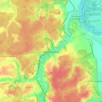
Name: Topografische Karte Jouet-sur-l'Aubois, Höhe, Relief.
Durchschnittliche Höhe: 187 m
Minimale Höhe: 156 m
Maximale Höhe: 211 m
Andere topografische Karten
Klicken Sie auf eine Karte, um ihre Topografie, ihre Höhe und ihr Relief anzuzeigen.
Crux
France > Centre-Val de Loire > Cher > Villequiers
Crux, Villequiers, Bourges, Cher, Centre-Val de Loire, Metropolitan France, 18800, France
Durchschnittliche Höhe: 196 m
Culan
France > Centre-Val de Loire > Cher
Culan, Saint-Amand-Montrond, Cher, Centre-Val de Loire, Metropolitan France, 18270, France
Durchschnittliche Höhe: 291 m
Bertrix
France > Centre-Val de Loire > Cher > Clémont
Bertrix, Clémont, Vierzon, Cher, Centre-Val de Loire, Metropolitan France, 18410, France
Durchschnittliche Höhe: 148 m
Mornay-sur-Allier
France > Centre-Val de Loire > Cher
Mornay-sur-Allier, Saint-Amand-Montrond, Cher, Centre-Val de Loire, Metropolitan France, 18600, France
Durchschnittliche Höhe: 199 m
Vernais
France > Centre-Val de Loire > Cher
Vernais, Saint-Amand-Montrond, Cher, Centre-Val de Loire, Metropolitan France, 18210, France
Durchschnittliche Höhe: 195 m
Ourouer-les-Bourdelins
France > Centre-Val de Loire > Cher
Ourouer-les-Bourdelins, Saint-Amand-Montrond, Cher, Centre-Val de Loire, Metropolitan France, 18350, France
Durchschnittliche Höhe: 208 m
Précy
France > Centre-Val de Loire > Cher
Précy, Bourges, Cher, Centre-Val de Loire, Metropolitan France, 18140, France
Durchschnittliche Höhe: 188 m
Le Chautay
France > Centre-Val de Loire > Cher
Le Chautay, Saint-Amand-Montrond, Cher, Centre-Val de Loire, Metropolitan France, 18150, France
Durchschnittliche Höhe: 193 m
Bué
France > Centre-Val de Loire > Cher
Bué, Bourges, Cher, Centre-Val de Loire, Metropolitan France, 18300, France
Durchschnittliche Höhe: 264 m
Bourges
France > Centre-Val de Loire > Cher
Bourges, Cher, Centre-Val de Loire, Metropolitan France, 18000, France
Durchschnittliche Höhe: 146 m
Marseilles
France > Centre-Val de Loire > Cher > Marseilles-lès-Aubigny
Marseilles, Marseilles-lès-Aubigny, Bourges, Cher, Centre-Val de Loire, Metropolitan France, 18320, France
Durchschnittliche Höhe: 177 m
Vierzon
France > Centre-Val de Loire > Cher
Vierzon, Cher, Centre-Val de Loire, Metropolitan France, 18100, France
Durchschnittliche Höhe: 137 m
Nohant-en-Graçay
France > Centre-Val de Loire > Cher
Nohant-en-Graçay, Vierzon, Cher, Centre-Val de Loire, Metropolitan France, 18310, France
Durchschnittliche Höhe: 138 m