
Spenden
Topografische Karte Blease Fell
Klicken Sie auf die Karte, um die Höhe anzuzeigen.
Spenden
Blease Fell
The Northern Fells make up a roughly circular upland area about 10 miles (16 km) wide. At the centre is the marshy depression of Skiddaw Forest — a treeless plateau at an altitude of 1,300 ft (400 m) — and flowing outward from here are the rivers which divide the area into three sectors. Between the Glenderaterra Beck and the River Caldew, the southeastern sector contains Blencathra and its satellites.
Spenden
Über diese Karte
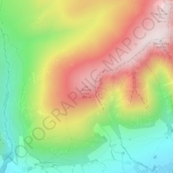
Name: Topografische Karte Blease Fell, Höhe, Relief.
Durchschnittliche Höhe: 482 m
Minimale Höhe: 149 m
Maximale Höhe: 854 m
Spenden
Andere topografische Karten
Klicken Sie auf eine Karte, um ihre Topografie, ihre Höhe und ihr Relief anzuzeigen.
River Glenderamackin
United Kingdom > England > Westmorland and Furness > Threlkeld
Durchschnittliche Höhe: 346 m