
Topografische Karte Chatsworth
Interaktive Karte
Klicken Sie auf die Karte, um die Höhe anzuzeigen.
Chatsworth
Chatsworth is located in central Murray County at 34°46′20″N 84°46′44″W / 34.77222°N 84.77889°W / 34.77222; -84.77889 (34.772336, -84.778977), in northwestern Georgia. It sits at an elevation of 750 feet (230 m) on the west side of the valley of Holly Creek, with 2,840-foot (870 m) Fort Mountain and 2,780-foot (850 m) Cohutta Mountain rising over the valley to the east.
Über diese Karte
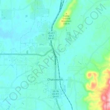
Name: Topografische Karte Chatsworth, Höhe, Relief.
Ort: Chatsworth, Murray County, Georgia, United States (34.74681 -84.82888 34.81781 -84.76255)
Durchschnittliche Höhe: 241 m
Minimale Höhe: 203 m
Maximale Höhe: 460 m
Andere topografische Karten
Klicken Sie auf eine Karte, um ihre Topografie, ihre Höhe und ihr Relief anzuzeigen.