
Topografische Karte Doublet Peak
Interaktive Karte
Klicken Sie auf die Karte, um die Höhe anzuzeigen.
Über diese Karte
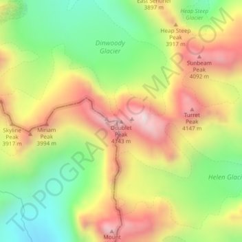
Name: Topografische Karte Doublet Peak, Höhe, Relief.
Ort: Doublet Peak, Fremont County, Wyoming, USA (43.16323 -109.62964 43.16333 -109.62954)
Durchschnittliche Höhe: 3.738 m
Minimale Höhe: 3.335 m
Maximale Höhe: 4.177 m
Andere topografische Karten
Klicken Sie auf eine Karte, um ihre Topografie, ihre Höhe und ihr Relief anzuzeigen.
Wind River Range
Wind River Range, Fremont County, Wyoming, USA
Durchschnittliche Höhe: 3.706 m
Mount Sacagawea
Mount Sacagawea, Fremont County, Wyoming, USA
Durchschnittliche Höhe: 3.667 m
Connie Glacier
Connie Glacier, Sublette County, Wyoming, USA
Durchschnittliche Höhe: 3.693 m
Airport Road
USA > Wyoming > Airport Road
Airport Road, Washakie County, Wyoming, 82401, USA
Durchschnittliche Höhe: 1.257 m
Continental Glacier
Continental Glacier, Fremont County, Wyoming, USA
Durchschnittliche Höhe: 3.768 m
Dinwoody Glacier
Dinwoody Glacier, Glacier Trail, Fremont County, Wyoming, USA
Durchschnittliche Höhe: 3.688 m
Knife Point Glacier
Knife Point Glacier, Indain Pass Trail, Sublette County, Wyoming, USA
Durchschnittliche Höhe: 3.638 m
Teepe Glacier
USA > Wyoming > Beaver Creek
Teepe Glacier, Garnet Canyon Trail, Beaver Creek, Teton County, Wyoming, USA
Durchschnittliche Höhe: 3.338 m
Hooker Glacier
Hooker Glacier, Baptiste Lake, Fremont County, Wyoming, USA
Durchschnittliche Höhe: 3.420 m
Mount Woodrow Wilson
Mount Woodrow Wilson, Sublette County, Wyoming, USA
Durchschnittliche Höhe: 3.710 m
Falling Ice Glacier
Falling Ice Glacier, Paintbrush Canyon, Teton County, Wyoming, USA
Durchschnittliche Höhe: 2.988 m
Sourdough Glacier
Sourdough Glacier, Sublette County, Wyoming, USA
Durchschnittliche Höhe: 3.701 m
Upper Fremont Glacier
Upper Fremont Glacier, Titcomb Basin Trail, Sublette County, Wyoming, USA
Durchschnittliche Höhe: 3.755 m
Lower Fremont Glacier
Lower Fremont Glacier, Indain Pass Trail, Sublette County, Wyoming, USA
Durchschnittliche Höhe: 3.706 m
Wind River Peak
Wind River Peak, Fremont County, Wyoming, USA
Durchschnittliche Höhe: 3.632 m
Klondike Lake
Klondike Lake, Glacier Trail, Fremont County, Wyoming, USA
Durchschnittliche Höhe: 3.579 m
Cloudveil Dome
Cloudveil Dome, Teton County, Wyoming, USA
Durchschnittliche Höhe: 3.199 m
Shoshone National Forest
Shoshone National Forest, Kirwin Trail, Park County, Wyoming, USA
Durchschnittliche Höhe: 2.163 m
Mammoth Glacier
Mammoth Glacier, Glacier Trail, Sublette County, Wyoming, USA
Durchschnittliche Höhe: 3.683 m
American Legion Peak
American Legion Peak, Sublette County, Wyoming, USA
Durchschnittliche Höhe: 3.606 m
Triple Glaciers
Triple Glaciers, Paintbrush Canyon, Teton County, Wyoming, USA
Durchschnittliche Höhe: 3.139 m
Yellowstone Lake
USA > Wyoming > Grant Village
Yellowstone Lake, I loop, Grant Village, Teton County, Wyoming, USA
Durchschnittliche Höhe: 2.453 m
Teton Glacier
USA > Wyoming > Beaver Creek
Teton Glacier, Garnet Canyon Trail, Beaver Creek, Teton County, Wyoming, USA
Durchschnittliche Höhe: 3.307 m
Downs Glacier
Downs Glacier, Fremont County, Wyoming, USA
Durchschnittliche Höhe: 3.727 m
Bighorn River
Bighorn River, Washakie County, Wyoming, USA
Durchschnittliche Höhe: 1.262 m
Skillet Glacier
Skillet Glacier, Trapper Lake Trail, Teton County, Wyoming, USA
Durchschnittliche Höhe: 2.959 m
Gooseneck Glacier
Gooseneck Glacier, Glacier Trail, Fremont County, Wyoming, USA
Durchschnittliche Höhe: 3.701 m
Klondike Peak
Klondike Peak, Sublette County, Wyoming, USA
Durchschnittliche Höhe: 3.696 m
Devils Tower National Monument
USA > Wyoming > Devils Tower
Devils Tower National Monument, Climbing Trail, Devils Tower, Crook County, Wyoming, 82714, USA
Durchschnittliche Höhe: 1.236 m
Fishhawk Glacier
Fishhawk Glacier, Park County, Wyoming, USA
Durchschnittliche Höhe: 3.218 m
Washakie Glacier
Washakie Glacier, Waskakie Pass Trail, Fremont County, Wyoming, USA
Durchschnittliche Höhe: 3.399 m
Lewis Lake
Lewis Lake, South Entrance Road, Teton County, Wyoming, USA
Durchschnittliche Höhe: 2.400 m
Helen Glacier
Helen Glacier, Titcomb Basin Trail, Sublette County, Wyoming, USA
Durchschnittliche Höhe: 3.702 m
Harrower Glacier
Harrower Glacier, Indain Pass Trail, Sublette County, Wyoming, USA
Durchschnittliche Höhe: 3.637 m
Middle Teton Glacier
USA > Wyoming > Beaver Creek
Middle Teton Glacier, Garnet Canyon Trail, Beaver Creek, Teton County, Wyoming, USA
Durchschnittliche Höhe: 3.383 m
Tiny Glacier
Tiny Glacier, Cook Lake Loop, Sublette County, Wyoming, USA
Durchschnittliche Höhe: 3.539 m
Mount Whitecap
Mount Whitecap, Sublette County, Wyoming, USA
Durchschnittliche Höhe: 3.528 m
Stroud Glacier
Stroud Glacier, Glacier Trail, Sublette County, Wyoming, USA
Durchschnittliche Höhe: 3.529 m
Medicine Bow Peak
Medicine Bow Peak, Albany County, Wyoming, USA
Durchschnittliche Höhe: 3.396 m