
Topografische Karte Ferrara
Interaktive Karte
Klicken Sie auf die Karte, um die Höhe anzuzeigen.
Über diese Karte
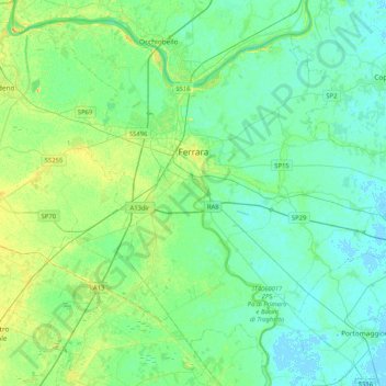
Name: Topografische Karte Ferrara, Höhe, Relief.
Ort: Ferrara, Emilia-Romagna, 44121-44124, Italy (44.67343 11.46306 44.93771 11.87702)
Durchschnittliche Höhe: 7 m
Minimale Höhe: -2 m
Maximale Höhe: 22 m
Andere topografische Karten
Klicken Sie auf eine Karte, um ihre Topografie, ihre Höhe und ihr Relief anzuzeigen.
Comacchio
Italy > Emilia-Romagna > Ferrara
Comacchio, Ferrara, Emilia-Romagna, Italy
Durchschnittliche Höhe: -1 m
Lido degli Scacchi
Italy > Emilia-Romagna > Ferrara > Comacchio
Lido degli Scacchi, Comacchio, Ferrara, Emilia-Romagna, 44022, Italy
Durchschnittliche Höhe: 0 m
Goro
Italy > Emilia-Romagna > Ferrara
Goro, Unione Delta del Po, Ferrara, Emilia-Romagna, Italy
Durchschnittliche Höhe: -2 m
Jolanda di Savoia
Italy > Emilia-Romagna > Ferrara
Jolanda di Savoia, Ferrara, Emilia-Romagna, 44037, Italy
Durchschnittliche Höhe: -2 m