
Spenden
Topografische Karte Dymchurch
Klicken Sie auf die Karte, um die Höhe anzuzeigen.
Spenden
Über diese Karte
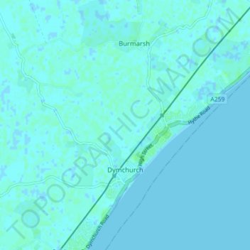
Name: Topografische Karte Dymchurch, Höhe, Relief.
Durchschnittliche Höhe: 1 m
Minimale Höhe: -2 m
Maximale Höhe: 6 m
Spenden
Andere topografische Karten
Klicken Sie auf eine Karte, um ihre Topografie, ihre Höhe und ihr Relief anzuzeigen.
Park Gate
United Kingdom > England > Kent > Folkestone and Hythe District > Elham
Durchschnittliche Höhe: 130 m
Spenden
Greatstone beach
United Kingdom > England > Kent > Folkestone and Hythe District > New Romney > Littlestone on Sea
Durchschnittliche Höhe: 2 m
The Warren
United Kingdom > England > Kent > Folkestone and Hythe District > Folkestone
Durchschnittliche Höhe: 46 m
Greatstone on Sea
United Kingdom > England > Kent > Folkestone and Hythe District > New Romney
Durchschnittliche Höhe: 2 m
Lydd-on-Sea
United Kingdom > England > Kent > Folkestone and Hythe District
Durchschnittliche Höhe: 2 m
Spenden
Ottinge
United Kingdom > England > Kent > Folkestone and Hythe District > Elham
Durchschnittliche Höhe: 133 m
Sandling
United Kingdom > England > Kent > Folkestone and Hythe District > Saltwood
Durchschnittliche Höhe: 77 m
Westenhanger
United Kingdom > England > Kent > Folkestone and Hythe District
Durchschnittliche Höhe: 80 m