
Topografische Karte Standard
Interaktive Karte
Klicken Sie auf die Karte, um die Höhe anzuzeigen.
Über diese Karte
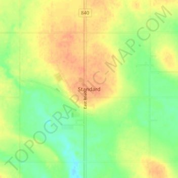
Name: Topografische Karte Standard, Höhe, Relief.
Ort: Standard, Wheatland County, Alberta, Canada (51.09245 -113.00021 51.13245 -112.96021)
Durchschnittliche Höhe: 889 m
Minimale Höhe: 869 m
Maximale Höhe: 906 m
Andere topografische Karten
Klicken Sie auf eine Karte, um ihre Topografie, ihre Höhe und ihr Relief anzuzeigen.
Wyndham-Carseland Provincial Park
Canada > Alberta > Wheatland County
Wyndham-Carseland Provincial Park, Wheatland County, Alberta, Canada
Durchschnittliche Höhe: 943 m
Siksika Nation
Canada > Alberta > Wheatland County
Siksika Nation, Wheatland County, Alberta, Canada
Durchschnittliche Höhe: 922 m
Cluny
Canada > Alberta > Wheatland County > Cluny
Cluny, Wheatland County, Alberta, T0J 0S0, Canada
Durchschnittliche Höhe: 891 m
Rosebud
Canada > Alberta > Wheatland County > Rosebud
Rosebud, Wheatland County, Alberta, Canada
Durchschnittliche Höhe: 824 m