
Topografische Karte Wayne County
Interaktive Karte
Klicken Sie auf die Karte, um die Höhe anzuzeigen.
Wayne County
According to the 2010 census, the county has a total area of 404.34 square miles (1,047.2 km2), of which 401.74 square miles (1,040.5 km2) (or 99.36%) is land and 2.60 square miles (6.7 km2) (or 0.64%) is water. Wayne County includes Indiana's highest natural elevation, Hoosier Hill, at 1,257 feet (383 m).
Über diese Karte
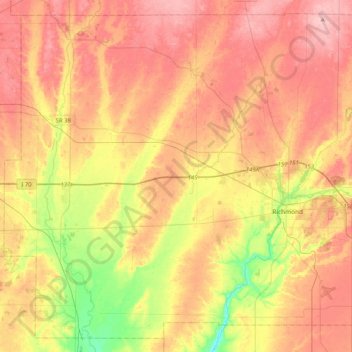
Name: Topografische Karte Wayne County, Höhe, Relief.
Ort: Wayne County, Indiana, United States (39.71477 -85.22151 40.00626 -84.81071)
Durchschnittliche Höhe: 322 m
Minimale Höhe: 240 m
Maximale Höhe: 385 m
Andere topografische Karten
Klicken Sie auf eine Karte, um ihre Topografie, ihre Höhe und ihr Relief anzuzeigen.
Indianapolis
United States > Indiana > Indianapolis
Indianapolis is within the Tipton Till Plain, a flat to gently sloping terrain underlain by glacial deposits known as till. The lowest point in the city is about 650 feet (198 m) above mean sea level, with the highest natural elevation at about 900 feet (274 m) above sea level. Few hills or short ridges, known…
Durchschnittliche Höhe: 241 m
Meridian Woods Park
United States > Indiana > Marion County > Indianapolis
Durchschnittliche Höhe: 216 m
Erskine Station
United States > Indiana > Vanderburgh County > Evansville
Durchschnittliche Höhe: 125 m
Johnson Lake
United States > Indiana > Jefferson County > Madison > North Madison
Durchschnittliche Höhe: 266 m
Fort Benjamin Harrison State Park and Nature Preserve
United States > Indiana > Marion County > Indianapolis
Durchschnittliche Höhe: 254 m
Indiana Dunes State Park
United States > Indiana > Porter County > Chesterton
Durchschnittliche Höhe: 186 m
Country Club Meadows
United States > Indiana > Vanderburgh County > Evansville
Durchschnittliche Höhe: 126 m