
Vielen Dank für die Unterstützung dieser Website ❤️
Spenden
Spenden
Topografische Karte Pocdol Mountains
Klicken Sie auf die Karte, um die Höhe anzuzeigen.
Vielen Dank für die Unterstützung dieser Website ❤️
Spenden
Spenden
Pocdol Mountains
The Pocdol Mountains form part of the boundary between the provinces of Albay and Sorsogon, in Region V, on the island of Luzon, in the Philippines. The group is located south-east of Mayon Volcano, between Albay Gulf and Sorsogon Bay, at 13°3'0"N, 123°57'30"E. The mountains have a triangular footprint of about 225 km2 (87 sq mi). There are several peaks above 1,000 m in elevation. The highest point is reported to be 1,102 m (3,615 ft) above sea level.
Vielen Dank für die Unterstützung dieser Website ❤️
Spenden
Spenden
Über diese Karte
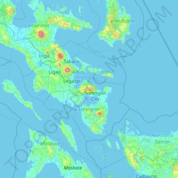
Name: Topografische Karte Pocdol Mountains, Höhe, Relief.
Durchschnittliche Höhe: 46 m
Minimale Höhe: -2 m
Maximale Höhe: 2.259 m
Vielen Dank für die Unterstützung dieser Website ❤️
Spenden
Spenden
Andere topografische Karten
Klicken Sie auf eine Karte, um ihre Topografie, ihre Höhe und ihr Relief anzuzeigen.