
Spenden
Topografische Karte Ben Macdui
Klicken Sie auf die Karte, um die Höhe anzuzeigen.
Spenden
Ben Macdui
Ben Macdui (Scottish Gaelic: Beinn Mac Duibh, meaning "Mac Duff's Hill") is the second-highest mountain in Scotland (and all of the British Isles) after Ben Nevis, and the highest in the Cairngorm Mountains and the wider Cairngorms National Park. The summit elevation is 1,309 metres (4,295 feet) AMSL. Ben Macdui lies on the southern edge of the Cairngorm plateau, on the boundary between the historic counties of Aberdeenshire and Banffshire (currently on the border between the Aberdeenshire and Moray council areas).
Spenden
Über diese Karte
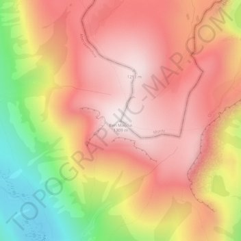
Name: Topografische Karte Ben Macdui, Höhe, Relief.
Ort: Ben Macdui, Aberdeenshire, Scotland, United Kingdom (57.07034 -3.66918 57.07044 -3.66908)
Durchschnittliche Höhe: 1.031 m
Minimale Höhe: 575 m
Maximale Höhe: 1.312 m
Spenden
Andere topografische Karten
Klicken Sie auf eine Karte, um ihre Topografie, ihre Höhe und ihr Relief anzuzeigen.