
Spenden
Topografische Karte Merrickville-Wolford
Klicken Sie auf die Karte, um die Höhe anzuzeigen.
Spenden
Über diese Karte
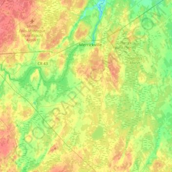
Name: Topografische Karte Merrickville-Wolford, Höhe, Relief.
Durchschnittliche Höhe: 113 m
Minimale Höhe: 89 m
Maximale Höhe: 140 m
Spenden
Andere topografische Karten
Klicken Sie auf eine Karte, um ihre Topografie, ihre Höhe und ihr Relief anzuzeigen.
Kemptville
Canada > Ontario > Leeds and Grenville Counties > North Grenville
Durchschnittliche Höhe: 97 m
Mallorytown Landing
Canada > Ontario > Leeds and Grenville Counties > Front of Yonge
Durchschnittliche Höhe: 86 m
Spenden
Groveton
Canada > Ontario > Leeds and Grenville Counties > Edwardsburgh/Cardinal
Durchschnittliche Höhe: 99 m
Lyn
Canada > Ontario > Leeds and Grenville Counties > Elizabethtown-Kitley
Durchschnittliche Höhe: 102 m
Spenden
Seeleys Bay
Canada > Ontario > Leeds and Grenville Counties > Leeds and the Thousand Islands > Seeley's Bay
Durchschnittliche Höhe: 105 m
Little Crosby Lake
Canada > Ontario > Leeds and Grenville Counties > Rideau Lakes
Durchschnittliche Höhe: 166 m
Johnstown
Canada > Ontario > Leeds and Grenville Counties > Edwardsburgh/Cardinal
Durchschnittliche Höhe: 83 m
Spenden
Lansdowne
Canada > Ontario > Leeds and Grenville Counties > Leeds and the Thousand Islands
Durchschnittliche Höhe: 101 m
Harvey Island
Canada > Ontario > Leeds and Grenville Counties > Elizabethtown-Kitley
Durchschnittliche Höhe: 111 m
Philipsville
Canada > Ontario > Leeds and Grenville Counties > Rideau Lakes
Durchschnittliche Höhe: 122 m
Spenden
Cardinal
Canada > Ontario > Leeds and Grenville Counties > Edwardsburgh/Cardinal
Durchschnittliche Höhe: 82 m
Tincap
Canada > Ontario > Leeds and Grenville Counties > Elizabethtown-Kitley
Durchschnittliche Höhe: 113 m
Actons Corners
Canada > Ontario > Leeds and Grenville Counties > North Grenville
Durchschnittliche Höhe: 97 m
Frankville
Canada > Ontario > Leeds and Grenville Counties > Elizabethtown-Kitley
Durchschnittliche Höhe: 118 m
Spenden
Merrickville
Canada > Ontario > Leeds and Grenville Counties > Merrickville-Wolford
Durchschnittliche Höhe: 114 m
Spectacle Lake
Canada > Ontario > Leeds and Grenville Counties > Rideau Lakes
Durchschnittliche Höhe: 189 m
Spenden
Spencerville
Canada > Ontario > Leeds and Grenville Counties > Edwardsburgh/Cardinal
Durchschnittliche Höhe: 99 m
Oxford Mills
Canada > Ontario > Leeds and Grenville Counties > North Grenville
Durchschnittliche Höhe: 103 m
Toledo
Canada > Ontario > Leeds and Grenville Counties > Elizabethtown-Kitley
Durchschnittliche Höhe: 121 m
Spenden
Waterton
Canada > Ontario > Leeds and Grenville Counties > Leeds and the Thousand Islands > Waterton
Durchschnittliche Höhe: 97 m
Seeley's Bay
Canada > Ontario > Leeds and Grenville Counties > Leeds and the Thousand Islands
Durchschnittliche Höhe: 106 m
Crosby
Canada > Ontario > Leeds and Grenville Counties > Rideau Lakes > Crosby
Durchschnittliche Höhe: 128 m
Greenbush
Canada > Ontario > Leeds and Grenville Counties > Elizabethtown-Kitley > Greenbush
Durchschnittliche Höhe: 120 m
Spenden
Motts Mills
Canada > Ontario > Leeds and Grenville Counties > Elizabethtown-Kitley
Durchschnittliche Höhe: 126 m
Codfish Island
Canada > Ontario > Leeds and Grenville Counties > Leeds and the Thousand Islands
Durchschnittliche Höhe: 79 m
Why Island
Canada > Ontario > Leeds and Grenville Counties > Leeds and the Thousand Islands
Durchschnittliche Höhe: 92 m
Spenden
Seeleys Bay
Canada > Ontario > Leeds and Grenville Counties > Leeds and the Thousand Islands > Seeley's Bay
Durchschnittliche Höhe: 105 m
Outlet
Canada > Ontario > Leeds and Grenville Counties > Leeds and the Thousand Islands
Durchschnittliche Höhe: 97 m
Glen Buell
Canada > Ontario > Leeds and Grenville Counties > Elizabethtown-Kitley
Durchschnittliche Höhe: 120 m
Spenden
Cardinal
Canada > Ontario > Leeds and Grenville Counties > Edwardsburgh/Cardinal
Durchschnittliche Höhe: 82 m