
Spenden
Topografische Karte Vrmac
Klicken Sie auf die Karte, um die Höhe anzuzeigen.
Spenden
Über diese Karte
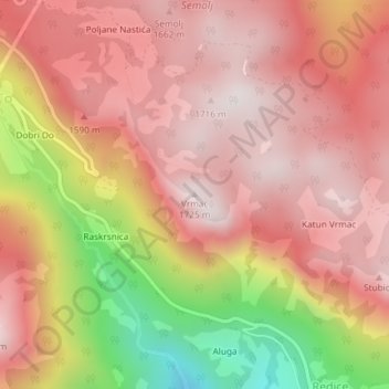
Name: Topografische Karte Vrmac, Höhe, Relief.
Ort: Vrmac, Kolašin Municipality, Montenegro (42.89354 19.28757 42.89364 19.28767)
Durchschnittliche Höhe: 1.432 m
Minimale Höhe: 864 m
Maximale Höhe: 1.717 m
Spenden
Andere topografische Karten
Klicken Sie auf eine Karte, um ihre Topografie, ihre Höhe und ihr Relief anzuzeigen.
Kolašin
Montenegro > Kolašin Municipality
Kolašin is located on the foot of Bjelasica and Sinjajevina mountains, which offer great conditions for skiing. Because of Kolašin's altitude (954 m), the town is considered an air spa.
Durchschnittliche Höhe: 1.000 m
Kolašin
Montenegro > Kolašin Municipality
Kolašin is located on the foot of Bjelasica and Sinjajevina mountains, which offer great conditions for skiing. Because of Kolašin's altitude (954 m), the town is considered an air spa.
Durchschnittliche Höhe: 1.000 m