
Spenden
Topografische Karte Collbató
Klicken Sie auf die Karte, um die Höhe anzuzeigen.
Spenden
Collbató
El relieve del municipio está caracterizado por la presencia del macizo de Montserrat y el Parque Natural de la Montaña de Montserrat, encontrándose el pueblo en una zona más llana situada al sur del mismo, en el valle formado por la riera de Can Dalmases. El territorio llega por el sur hasta la sierra de Fosalba, que incluye el pico Dolcet (419 metros), en el límite con Els Hostalets de Pierola. El río Llobregat y su cuenca marcan el límite natural por el noreste. El término municipal llega por el norte hasta las cercanías de la cima de Sant Jeroni (1224 metros) y el recinto del santuario de Montserrat. La altitud oscila entre los 1150 metros al norte, en pleno macizo de Montserrat, y los 120 metros al noreste, a orillas del río Llobregat. El pueblo se alza a 439 metros sobre el nivel del mar.
Spenden
Über diese Karte
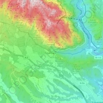
Name: Topografische Karte Collbató, Höhe, Relief.
Ort: Collbató, Bajo Llobregat, Barcelona, Cataluña, 08293, España (41.53899 1.79435 41.60297 1.86098)
Durchschnittliche Höhe: 427 m
Minimale Höhe: 85 m
Maximale Höhe: 1.151 m
Spenden
Andere topografische Karten
Klicken Sie auf eine Karte, um ihre Topografie, ihre Höhe und ihr Relief anzuzeigen.
Spenden
Santa Coloma de Cervelló
España > Cataluña > Bajo Llobregat > Santa Coloma de Cervelló > Santa Coloma de Cervelló
Durchschnittliche Höhe: 79 m
Cornellà de Llobregat
España > Cataluña > Bajo Llobregat > Cornellà de Llobregat > Cornellà de Llobregat
El relieve es prácticamente llano, oscilando la altitud entre los 67 metros al norte y los 9 metros a orillas del Llobregat. El casco histórico se alza a 27 metros sobre el nivel del mar.
Durchschnittliche Höhe: 39 m
Esplugues de Llobregat
España > Cataluña > Bajo Llobregat > Esplugues de Llobregat > Esplugues de Llobregat
Durchschnittliche Höhe: 97 m
Spenden
Spenden
Plaza Cataluña
España > Cataluña > Bajo Llobregat > Cornellà de Llobregat
Durchschnittliche Höhe: 35 m
Agulles del Petintó inferior (Espases de Sant Salvador)
España > Cataluña > Bajo Llobregat > Olesa de Montserrat
Durchschnittliche Höhe: 291 m
Spenden
Pou del Merlí
España > Cataluña > Bajo Llobregat > Martorell > Pou del Merlí
Durchschnittliche Höhe: 112 m
Sant Climent de Llobregat
España > Cataluña > Bajo Llobregat > Sant Climent de Llobregat
Durchschnittliche Höhe: 148 m
Spenden