
Vielen Dank für die Unterstützung dieser Website ❤️
Spenden
Spenden
Topografische Karte Livingston
Klicken Sie auf die Karte, um die Höhe anzuzeigen.
Vielen Dank für die Unterstützung dieser Website ❤️
Spenden
Spenden
Livingston
Livingston is located at 45°39′32″N 110°33′49″W / 45.65889°N 110.56361°W / 45.65889; -110.56361 (45.658840, -110.563718), at an elevation of 4,501 feet (1372 m).
Vielen Dank für die Unterstützung dieser Website ❤️
Spenden
Spenden
Über diese Karte
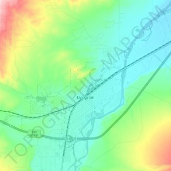
Name: Topografische Karte Livingston, Höhe, Relief.
Ort: Livingston, Park County, Montana, 59047, United States (45.63640 -110.61293 45.69848 -110.50695)
Durchschnittliche Höhe: 1.421 m
Minimale Höhe: 1.349 m
Maximale Höhe: 1.608 m
Vielen Dank für die Unterstützung dieser Website ❤️
Spenden
Spenden
Andere topografische Karten
Klicken Sie auf eine Karte, um ihre Topografie, ihre Höhe und ihr Relief anzuzeigen.