
Topografische Karte Stafford Center
Interaktive Karte
Klicken Sie auf die Karte, um die Höhe anzuzeigen.
Über diese Karte
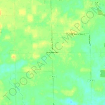
Name: Topografische Karte Stafford Center, Höhe, Relief.
Durchschnittliche Höhe: 258 m
Minimale Höhe: 245 m
Maximale Höhe: 270 m
Andere topografische Karten
Klicken Sie auf eine Karte, um ihre Topografie, ihre Höhe und ihr Relief anzuzeigen.
Spencerville
United States > Indiana > DeKalb County
Spencerville, DeKalb County, Indiana, 46788, United States
Durchschnittliche Höhe: 249 m
Corunna
United States > Indiana > DeKalb County
Corunna, DeKalb County, Indiana, United States
Durchschnittliche Höhe: 295 m
Altona
United States > Indiana > DeKalb County
Altona, DeKalb County, Indiana, United States
Durchschnittliche Höhe: 271 m
Ashley
United States > Indiana > DeKalb County
Ashley, DeKalb County, Indiana, 46705, United States
Durchschnittliche Höhe: 303 m
Butler
United States > Indiana > DeKalb County
Butler, DeKalb County, Indiana, United States
Durchschnittliche Höhe: 265 m
St. Joe
United States > Indiana > DeKalb County
St. Joe, DeKalb County, Indiana, United States
Durchschnittliche Höhe: 250 m
Waterloo
United States > Indiana > DeKalb County
Waterloo, DeKalb County, Indiana, United States
Durchschnittliche Höhe: 276 m
Garrett
United States > Indiana > DeKalb County
Garrett, DeKalb County, Indiana, 46738, United States
Durchschnittliche Höhe: 270 m