
Topografische Karte Papplewick CP
Klicken Sie auf die Karte, um die Höhe anzuzeigen.
Über diese Karte
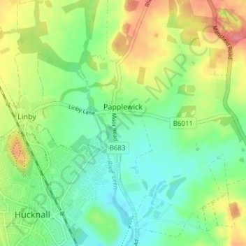
Name: Topografische Karte Papplewick CP, Höhe, Relief.
Durchschnittliche Höhe: 87 m
Minimale Höhe: 57 m
Maximale Höhe: 137 m
Andere topografische Karten
Klicken Sie auf eine Karte, um ihre Topografie, ihre Höhe und ihr Relief anzuzeigen.
Arnold
United Kingdom > England > Nottinghamshire > Gedling
The local topography suggests that Arnold can never have been a haunt of eagles, because they inhabit areas of rocky outcrops, which have formed cliffs: the nearest such location is Creswell Crags, some 20 miles (32 km) north-west as the eagle flies. However, the fish-eating white-tailed eagle (also known as…
Durchschnittliche Höhe: 81 m
Dorket Head
United Kingdom > England > Nottinghamshire > Gedling > Arnold
Durchschnittliche Höhe: 113 m
Gedling Country Park
United Kingdom > England > Nottinghamshire > Gedling > Carlton
Durchschnittliche Höhe: 80 m
Lambley Lane Recreation Ground (North)
United Kingdom > England > Nottinghamshire > Gedling > Carlton
Durchschnittliche Höhe: 73 m
Colwick Country Park
United Kingdom > England > Nottinghamshire > Gedling > Carlton > Colwick
Durchschnittliche Höhe: 32 m