
Topografische Karte Rognée
Interaktive Karte
Klicken Sie auf die Karte, um die Höhe anzuzeigen.
Über diese Karte
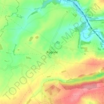
Name: Topografische Karte Rognée, Höhe, Relief.
Ort: Rognée, Walcourt, Philippeville, Namen, Wallonië, 5651, België (50.24915 4.36921 50.28915 4.40921)
Durchschnittliche Höhe: 188 m
Minimale Höhe: 147 m
Maximale Höhe: 241 m
Andere topografische Karten
Klicken Sie auf eine Karte, um ihre Topografie, ihre Höhe und ihr Relief anzuzeigen.
Thy-le-Château
België > Namen > Philippeville > Walcourt
Thy-le-Château, Walcourt, Philippeville, Namen, Wallonië, 5651, België
Durchschnittliche Höhe: 193 m
Berzée
België > Namen > Philippeville > Walcourt
Berzée, Walcourt, Philippeville, Namen, Wallonië, 5651, België
Durchschnittliche Höhe: 182 m
Tarcienne
België > Namen > Philippeville > Walcourt
Tarcienne, Walcourt, Philippeville, Namen, Wallonië, 5651, België
Durchschnittliche Höhe: 224 m
Gourdinne
België > Namen > Philippeville > Walcourt
Gourdinne, Walcourt, Philippeville, Namen, Wallonië, 5651, België
Durchschnittliche Höhe: 208 m
Somzée
België > Namen > Philippeville > Walcourt
Somzée, Walcourt, Philippeville, Namen, Wallonië, 5651, België
Durchschnittliche Höhe: 217 m
Fraire
België > Namen > Philippeville > Walcourt
Fraire, Walcourt, Philippeville, Namen, Wallonië, 5650, België
Durchschnittliche Höhe: 248 m
Yves-Gomezée
België > Namen > Philippeville > Walcourt
Yves-Gomezée, Walcourt, Philippeville, Namen, Wallonië, 5650, België
Durchschnittliche Höhe: 242 m
Chastrès
België > Namen > Philippeville > Walcourt
Chastrès, Walcourt, Philippeville, Namen, Wallonië, 5650, België
Durchschnittliche Höhe: 210 m