
Topografische Karte North Slope
Interaktive Karte
Klicken Sie auf die Karte, um die Höhe anzuzeigen.
Über diese Karte
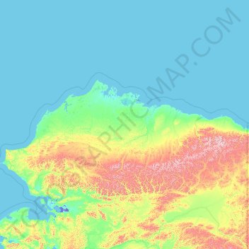
Name: Topografische Karte North Slope, Höhe, Relief.
Ort: North Slope, Alaska, United States of America (67.99894 -166.98551 71.44106 -141.00059)
Durchschnittliche Höhe: 214 m
Minimale Höhe: -9 m
Maximale Höhe: 2.518 m
Andere topografische Karten
Klicken Sie auf eine Karte, um ihre Topografie, ihre Höhe und ihr Relief anzuzeigen.
Kodiak Island
United States of America > Alaska
Kodiak Island, Alaska, United States of America
Durchschnittliche Höhe: 84 m
Southeast Fairbanks
United States of America > Alaska > Copper Center
Southeast Fairbanks, Richardson Highway, Copper Center, Unorganized Borough, Alaska, United States of America
Durchschnittliche Höhe: 856 m
Aleutians East
United States of America > Alaska
Aleutians East, Alaska, United States of America
Durchschnittliche Höhe: 23 m