
Spenden
Topografische Karte Dokis Island
Klicken Sie auf die Karte, um die Höhe anzuzeigen.
Spenden
Über diese Karte
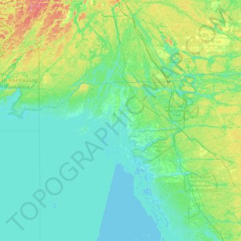
Name: Topografische Karte Dokis Island, Höhe, Relief.
Durchschnittliche Höhe: 196 m
Minimale Höhe: 172 m
Maximale Höhe: 303 m
Spenden
Andere topografische Karten
Klicken Sie auf eine Karte, um ihre Topografie, ihre Höhe und ihr Relief anzuzeigen.
Magnetawan River
Canada > Ontario > Parry Sound District > Unorganized Centre Parry Sound
Durchschnittliche Höhe: 198 m
Pickerel River
Canada > Ontario > Parry Sound District > Unorganized Centre Parry Sound
Durchschnittliche Höhe: 200 m
Harris Lake
Canada > Ontario > Parry Sound District > Unorganized Centre Parry Sound
Durchschnittliche Höhe: 209 m
Ferguson Island
Canada > Ontario > Parry Sound District > Unorganized Centre Parry Sound
Durchschnittliche Höhe: 206 m
Spenden
Cole Lake
Canada > Ontario > Parry Sound District > Unorganized Centre Parry Sound
Durchschnittliche Höhe: 216 m
Grundy Lake Provincial Park
Canada > Ontario > Parry Sound District > Unorganized Centre Parry Sound
Durchschnittliche Höhe: 197 m
Key River
Canada > Ontario > Parry Sound District > Unorganized Centre Parry Sound
Durchschnittliche Höhe: 194 m
Culin Lake
Canada > Ontario > Parry Sound District > Unorganized Centre Parry Sound > Arnstein
Durchschnittliche Höhe: 230 m
Spenden
Bob's Lake
Canada > Ontario > Parry Sound District > Unorganized Centre Parry Sound
Durchschnittliche Höhe: 255 m
Spring Lake
Canada > Ontario > Parry Sound District > Unorganized Centre Parry Sound
Durchschnittliche Höhe: 317 m
Restoule Lake
Canada > Ontario > Parry Sound District > Unorganized Centre Parry Sound
Durchschnittliche Höhe: 245 m
Key River
Canada > Ontario > Parry Sound District > Unorganized Centre Parry Sound
Durchschnittliche Höhe: 193 m
Spenden