
Spenden
Topografische Karte Claveria
Klicken Sie auf die Karte, um die Höhe anzuzeigen.
Spenden
Claveria
The town has a generally rugged topography, characterized by gently rolling hills and mountains with cliffs and escarpments. The soil is classified as Jasaan clay, with a deep soil profile (greater than 1 m) and rapid drainage. It is generally acidic (pH 3.9 to 5.2), with low cation exchange capacity (CEC), low to moderate organic matter content (1.8%), high aluminium saturation, and low levels of available phosphorus and exchangeable potassium.
Spenden
Über diese Karte
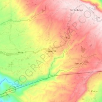
Name: Topografische Karte Claveria, Höhe, Relief.
Durchschnittliche Höhe: 663 m
Minimale Höhe: 255 m
Maximale Höhe: 950 m
Spenden
Andere topografische Karten
Klicken Sie auf eine Karte, um ihre Topografie, ihre Höhe und ihr Relief anzuzeigen.
Spenden
Cagayan de Oro River
Philippines > Misamis Oriental > Cagayan De Oro > Balulang
Durchschnittliche Höhe: 98 m
Spenden
Spenden
Spenden