
Topografische Karte Gloucester County
Interaktive Karte
Klicken Sie auf die Karte, um die Höhe anzuzeigen.
Über diese Karte
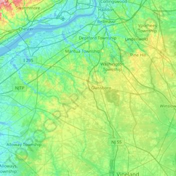
Name: Topografische Karte Gloucester County, Höhe, Relief.
Ort: Gloucester County, New Jersey, United States (39.51480 -75.44845 39.88797 -74.87719)
Durchschnittliche Höhe: 26 m
Minimale Höhe: -4 m
Maximale Höhe: 125 m
As of the 2010 U.S. census, Gloucester County had a total area of 337.18 square miles (873.3 km2), including 322.00 square miles (834.0 km2) of land (95.5%) and 15.17 square miles (39.3 km2) of water (4.5%). Gloucester County is largely comprised of low-lying rivers and coastal plains. The highest elevation in the county is a slight rise on County Road 654 southeast of Monroe Township that rises to approximately 180 feet (55 m) above sea level] The county's lowest elevation is at sea level on the Delaware River.
Andere topografische Karten
Klicken Sie auf eine Karte, um ihre Topografie, ihre Höhe und ihr Relief anzuzeigen.
Bridgewater Township
United States > New Jersey > Somerset County
Bridgewater Township, Somerset County, New Jersey, United States
Durchschnittliche Höhe: 58 m
Coxs Corner
United States > New Jersey > Burlington County > Mount Laurel Township
Coxs Corner, Mount Laurel Township, Burlington County, New Jersey, 08054, United States
Durchschnittliche Höhe: 21 m
Ocean City
United States > New Jersey > Cape May County
Ocean City, Cape May County, New Jersey, United States
Durchschnittliche Höhe: 1 m
Jersey City
United States > New Jersey > Hudson County
Jersey City, Hudson County, New Jersey, United States
Durchschnittliche Höhe: 9 m
Morris County
Morris County, New Jersey, United States
Durchschnittliche Höhe: 182 m
Summit
United States > New Jersey > Union County
Summit, Union County, New Jersey, United States
Durchschnittliche Höhe: 97 m
Corson's Inlet State Park
United States > New Jersey > Cape May County > Upper Township > Strathmere
Corson's Inlet State Park, Seaview Drive, Strathmere, Upper Township, Cape May County, New Jersey, 08248, United States
Durchschnittliche Höhe: 1 m
Toms River
United States > New Jersey > Ocean County
Toms River, Ocean County, New Jersey, United States
Durchschnittliche Höhe: 14 m
Princeton
United States > New Jersey > Mercer County
Princeton, Mercer County, New Jersey, United States
Durchschnittliche Höhe: 45 m
Sparta
United States > New Jersey > Sussex County > Sparta Township > Sparta
Sparta, Sparta Township, Sussex County, New Jersey, 07871, United States
Durchschnittliche Höhe: 276 m
Mystic Islands
United States > New Jersey > Ocean County > Little Egg Harbor Township
Mystic Islands, Little Egg Harbor Township, Ocean County, New Jersey, 08087, United States
Durchschnittliche Höhe: 1 m
Vernon Township
United States > New Jersey > Sussex County
Vernon Township, Sussex County, New Jersey, United States
Durchschnittliche Höhe: 253 m
Rockaway Township
United States > New Jersey > Morris County > Rockaway Township
Rockaway Township, Morris County, New Jersey, United States
Durchschnittliche Höhe: 252 m
Livingston
United States > New Jersey > Essex County
Livingston, Essex County, New Jersey, 07039, United States
Durchschnittliche Höhe: 104 m
Union County
Union County, New Jersey, United States
Durchschnittliche Höhe: 45 m
Edison
United States > New Jersey > Middlesex County
Edison, Middlesex County, New Jersey, United States
Durchschnittliche Höhe: 25 m
Warbasse
United States > New Jersey > Sussex County > Lafayette Township
Warbasse, Lafayette Township, Sussex County, New Jersey, 07848, United States
Durchschnittliche Höhe: 186 m
Essex County
Essex County, New Jersey, United States
Durchschnittliche Höhe: 60 m
Hardwick Township
United States > New Jersey > Warren County
Hardwick Township, Warren County, New Jersey, United States
Durchschnittliche Höhe: 216 m
Squankum
United States > New Jersey > Monmouth County > Howell Township
Squankum, Howell Township, Monmouth County, New Jersey, 08776, United States
Durchschnittliche Höhe: 19 m
Ardena
United States > New Jersey > Monmouth County > Howell Township
Ardena, Howell Township, Monmouth County, New Jersey, 07710, United States
Durchschnittliche Höhe: 32 m
Lanoka Harbor
United States > New Jersey > Ocean County > Lacey Township
Lanoka Harbor, Lacey Township, Ocean County, New Jersey, 08734, United States
Durchschnittliche Höhe: 7 m
Montclair
United States > New Jersey > Essex County
Montclair, Essex County, New Jersey, United States
Durchschnittliche Höhe: 108 m
Wayne
United States > New Jersey > Passaic County
Wayne, Passaic County, New Jersey, 07470, United States
Durchschnittliche Höhe: 86 m
Northfield
United States > New Jersey > Essex County > Livingston
Northfield, Livingston, Essex County, New Jersey, 07039, United States
Durchschnittliche Höhe: 90 m
Dover Forge
United States > New Jersey > Ocean County > Berkeley Township
Dover Forge, Berkeley Township, Ocean County, New Jersey, United States
Durchschnittliche Höhe: 20 m
West Deptford Township
United States > New Jersey > Gloucester County
West Deptford Township, Gloucester County, New Jersey, United States
Durchschnittliche Höhe: 9 m
Brick Township
United States > New Jersey > Ocean County
Brick Township, Ocean County, New Jersey, United States
Durchschnittliche Höhe: 10 m
Whiting
United States > New Jersey > Ocean County > Manchester Township
Whiting, Manchester Township, Ocean County, New Jersey, United States
Durchschnittliche Höhe: 47 m
Pine Hill
United States > New Jersey > Camden County
Pine Hill, Camden County, New Jersey, 08021, United States
Durchschnittliche Höhe: 39 m
Cold Spring
United States > New Jersey > Cape May County > Lower Township
Cold Spring, Lower Township, Cape May County, New Jersey, 08204, United States
Durchschnittliche Höhe: 4 m
Cranberry Hill
United States > New Jersey > Ocean County > Lacey Township > Forked River
Cranberry Hill, Forked River, Lacey Township, Ocean County, New Jersey, 08731, United States
Durchschnittliche Höhe: 10 m
Morristown
United States > New Jersey > Morris County
Morristown, Morris County, New Jersey, 07960, United States
Durchschnittliche Höhe: 118 m
Plainfield
United States > New Jersey > Union County
Plainfield, Union County, New Jersey, United States
Durchschnittliche Höhe: 43 m
Herbertsville
United States > New Jersey > Ocean County > Brick Township
Herbertsville, Brick Township, Ocean County, New Jersey, 08724, United States
Durchschnittliche Höhe: 14 m
Stillwater
United States > New Jersey > Sussex County > Stillwater Township
Stillwater, Stillwater Township, Sussex County, New Jersey, 07855, United States
Durchschnittliche Höhe: 173 m
Eagle Rock Reservation
United States > New Jersey > Essex County > West Orange
Eagle Rock Reservation, West Orange, Essex County, New Jersey, United States
Durchschnittliche Höhe: 144 m
The Highlands
United States > New Jersey > Morris County > Chatham Township
The Highlands, Chatham Township, Morris County, New Jersey, 07974, United States
Durchschnittliche Höhe: 85 m
The Orchards
United States > New Jersey > Mercer County > Hamilton Township
The Orchards, Hamilton Township, Mercer County, New Jersey, 08619, United States
Durchschnittliche Höhe: 22 m
Allenhurst
United States > New Jersey > Monmouth County
Allenhurst, Monmouth County, New Jersey, United States
Durchschnittliche Höhe: 5 m
Burlington County
Burlington County, New Jersey, United States
Durchschnittliche Höhe: 27 m
North Stelton
United States > New Jersey > Middlesex County > Piscataway Township
North Stelton, Piscataway Township, Middlesex County, New Jersey, 08817, United States
Durchschnittliche Höhe: 29 m
Audubon
United States > New Jersey > Camden County
Audubon, Camden County, New Jersey, 08106, United States
Durchschnittliche Höhe: 15 m
Camden
United States > New Jersey > Camden County
Camden, Camden County, New Jersey, United States
Durchschnittliche Höhe: 7 m
Penbryn
United States > New Jersey > Camden County > Winslow Township
Penbryn, Winslow Township, Camden County, New Jersey, 08009, United States
Durchschnittliche Höhe: 45 m
Mystic Island
United States > New Jersey > Ocean County > Little Egg Harbor Township
Mystic Island, Little Egg Harbor Township, Ocean County, New Jersey, United States
Durchschnittliche Höhe: 3 m
Jacksonville
United States > New Jersey > Morris County > Kinnelon
Jacksonville, Kinnelon, Morris County, New Jersey, 07444, United States
Durchschnittliche Höhe: 110 m
Dennisville
United States > New Jersey > Cape May County > Dennis Township
Dennisville, Dennis Township, Cape May County, New Jersey, 08214, United States
Durchschnittliche Höhe: 3 m
Independence Township
United States > New Jersey > Warren County
Independence Township, Warren County, New Jersey, United States
Durchschnittliche Höhe: 215 m
Trenton
United States > New Jersey > Mercer County
Trenton, Mercer County, New Jersey, United States
Durchschnittliche Höhe: 19 m