
Topografische Karte Croxden
Interaktive Karte
Klicken Sie auf die Karte, um die Höhe anzuzeigen.
Über diese Karte
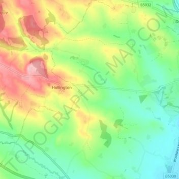
Name: Topografische Karte Croxden, Höhe, Relief.
Durchschnittliche Höhe: 137 m
Minimale Höhe: 81 m
Maximale Höhe: 225 m
Andere topografische Karten
Klicken Sie auf eine Karte, um ihre Topografie, ihre Höhe und ihr Relief anzuzeigen.
Gratwich
United Kingdom > England > Staffordshire > East Staffordshire > Kingstone
Gratwich, Kingstone, East Staffordshire, Staffordshire, England, ST14 8WE, United Kingdom
Durchschnittliche Höhe: 143 m
Fauld
United Kingdom > England > Staffordshire > East Staffordshire > Hanbury
Fauld, Hanbury, East Staffordshire, Staffordshire, England, DE13 9HT, United Kingdom
Durchschnittliche Höhe: 88 m
Burton-on-Trent
United Kingdom > England > Staffordshire > East Staffordshire
Burton-on-Trent, East Staffordshire, Staffordshire, England, DE14 1JN, United Kingdom
Durchschnittliche Höhe: 69 m
Stanton
United Kingdom > England > Staffordshire > East Staffordshire
Stanton, East Staffordshire, Staffordshire, England, DE6 2DA, United Kingdom
Durchschnittliche Höhe: 222 m
Birch Cross
United Kingdom > England > Staffordshire > East Staffordshire > Marchington
Birch Cross, Marchington, East Staffordshire, Staffordshire, England, ST14 8NX, United Kingdom
Durchschnittliche Höhe: 92 m
Stubwood
United Kingdom > England > Staffordshire > East Staffordshire > Denstone
Stubwood, Denstone, East Staffordshire, Staffordshire, England, ST14 5HX, United Kingdom
Durchschnittliche Höhe: 113 m
Denstone
United Kingdom > England > Staffordshire > East Staffordshire
Denstone, East Staffordshire, Staffordshire, England, United Kingdom
Durchschnittliche Höhe: 121 m
Tutbury Castle
United Kingdom > England > Staffordshire > East Staffordshire > Tutbury
Tutbury Castle, Castle Street, Tutbury, East Staffordshire, Staffordshire, England, DE13 9JF, United Kingdom
Durchschnittliche Höhe: 66 m
Shobnall
United Kingdom > England > Staffordshire > East Staffordshire > Burton-on-Trent
Shobnall, Burton-on-Trent, East Staffordshire, Staffordshire, England, United Kingdom
Durchschnittliche Höhe: 56 m
Harlow Wood
United Kingdom > England > Staffordshire > East Staffordshire > Upper Mayfield
Harlow Wood, Stanton, Upper Mayfield, East Staffordshire, Staffordshire, England, United Kingdom
Durchschnittliche Höhe: 177 m
Draycott in the Clay
United Kingdom > England > Staffordshire > East Staffordshire > Draycott in the Clay
Draycott in the Clay, East Staffordshire, Staffordshire, West Midlands, England, United Kingdom
Durchschnittliche Höhe: 90 m
Tutbury
United Kingdom > England > Staffordshire > East Staffordshire
Tutbury, East Staffordshire, Staffordshire, England, United Kingdom
Durchschnittliche Höhe: 80 m
Rolleston on Dove
United Kingdom > England > Staffordshire > East Staffordshire
Rolleston on Dove, East Staffordshire, Staffordshire, England, United Kingdom
Durchschnittliche Höhe: 61 m
Bramshall
United Kingdom > England > Staffordshire > East Staffordshire > Bramshall
Bramshall, East Staffordshire, Staffordshire, West Midlands, England, ST14 5DE, United Kingdom
Durchschnittliche Höhe: 121 m
Hanbury
United Kingdom > England > Staffordshire > East Staffordshire
Hanbury, East Staffordshire, Staffordshire, England, United Kingdom
Durchschnittliche Höhe: 107 m
Blithfield Reservoir
United Kingdom > England > Staffordshire > East Staffordshire > Admaston
Blithfield Reservoir, Admaston, East Staffordshire, Staffordshire, West Midlands, England, United Kingdom
Durchschnittliche Höhe: 108 m
Yoxall
United Kingdom > England > Staffordshire > East Staffordshire > Yoxall
Yoxall, East Staffordshire, Staffordshire, West Midlands, England, United Kingdom
Durchschnittliche Höhe: 89 m
Hoar Cross
United Kingdom > England > Staffordshire > East Staffordshire > Hoar Cross
Hoar Cross, East Staffordshire, Staffordshire, West Midlands, England, United Kingdom
Durchschnittliche Höhe: 110 m
Barton-under-Needwood
United Kingdom > England > Staffordshire > East Staffordshire
Barton-under-Needwood, East Staffordshire, Staffordshire, England, United Kingdom
Durchschnittliche Höhe: 69 m
Abbots Bromley
United Kingdom > England > Staffordshire > East Staffordshire
Abbots Bromley, East Staffordshire, Staffordshire, England, United Kingdom
Durchschnittliche Höhe: 114 m
Uttoxeter
United Kingdom > England > Staffordshire > East Staffordshire
Uttoxeter, East Staffordshire, Staffordshire, England, United Kingdom
Durchschnittliche Höhe: 100 m
Rocester
United Kingdom > England > Staffordshire > East Staffordshire
Rocester, East Staffordshire, Staffordshire, England, United Kingdom
Durchschnittliche Höhe: 105 m
Stapenhill
United Kingdom > England > Staffordshire > East Staffordshire
Stapenhill, East Staffordshire, Staffordshire, England, United Kingdom
Durchschnittliche Höhe: 67 m
Ellastone
United Kingdom > England > Staffordshire > East Staffordshire
Ellastone, East Staffordshire, Staffordshire, England, DE6 2GZ, United Kingdom
Durchschnittliche Höhe: 141 m
Anslow
United Kingdom > England > Staffordshire > East Staffordshire
Anslow, East Staffordshire, Staffordshire, England, United Kingdom
Durchschnittliche Höhe: 88 m