
Spenden
Topografische Karte Hopkins Spring
Klicken Sie auf die Karte, um die Höhe anzuzeigen.
Spenden
Über diese Karte
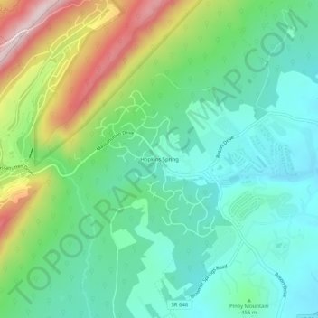
Name: Topografische Karte Hopkins Spring, Höhe, Relief.
Durchschnittliche Höhe: 466 m
Minimale Höhe: 340 m
Maximale Höhe: 755 m
Spenden
Andere topografische Karten
Klicken Sie auf eine Karte, um ihre Topografie, ihre Höhe und ihr Relief anzuzeigen.
Port Republic
United States > Virginia > Rockingham County > Port Republic
Durchschnittliche Höhe: 339 m
Spenden
Harrisonburg/Warm Springs Turnpike Park
United States > Virginia > Rockingham County > Bridgewater
Durchschnittliche Höhe: 378 m
McGaheysville
United States > Virginia > Rockingham County > McGaheysville
Durchschnittliche Höhe: 364 m
Spenden
Port Republic
United States > Virginia > Rockingham County > Port Republic
Durchschnittliche Höhe: 339 m
Belmont Estates
United States > Virginia > Rockingham County > Belmont Estates
Durchschnittliche Höhe: 410 m
Spenden
Bridgewater
United States > Virginia > Rockingham County
According to the United States Census Bureau, the town has a total area of 2.52 sq mi (6.5 km2), nearly all of it being land. Most of the town is located within a bend of the North River. Floods have wrecked the town occasionally. The northern areas are partly shielded from flooding with an Army Corps of…
Durchschnittliche Höhe: 380 m