
Topografische Karte Cromwell Community
Interaktive Karte
Klicken Sie auf die Karte, um die Höhe anzuzeigen.
Über diese Karte
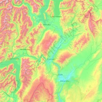
Name: Topografische Karte Cromwell Community, Höhe, Relief.
Durchschnittliche Höhe: 876 m
Minimale Höhe: 133 m
Maximale Höhe: 2.593 m
Andere topografische Karten
Klicken Sie auf eine Karte, um ihre Topografie, ihre Höhe und ihr Relief anzuzeigen.
Central Otago
New Zealand > Otago > Central Otago District > Vincent Community
Central Otago, Vincent Community, Central Otago District, Otago, 9035, New Zealand
Durchschnittliche Höhe: 935 m
Alexandra
New Zealand > Otago > Central Otago District > Vincent Community
Alexandra, Vincent Community, Central Otago District, Otago, 9320, New Zealand
Durchschnittliche Höhe: 241 m
Cromwell
New Zealand > Otago > Central Otago District > Cromwell Community > Cromwell
Cromwell, Cromwell Community, Central Otago District, Otago, 9310, New Zealand
Durchschnittliche Höhe: 330 m
Roxburgh
New Zealand > Otago > Central Otago District > Teviot Valley Community
Roxburgh, Teviot Valley Community, Central Otago District, Otago, 9500, New Zealand
Durchschnittliche Höhe: 223 m