
Vielen Dank für die Unterstützung dieser Website ❤️
Spenden
Spenden
Topografische Karte Naujan Lake
Klicken Sie auf die Karte, um die Höhe anzuzeigen.
Vielen Dank für die Unterstützung dieser Website ❤️
Spenden
Spenden
Naujan Lake
Mount Naujan, elevation 1,380 feet (420 m) and one of the inactive volcanoes of the country, is situated northeast of the geographic center of the lake. Several thermal springs and solfataras are reported to exist on the eastern border of the Naujan Lake.
Vielen Dank für die Unterstützung dieser Website ❤️
Spenden
Spenden
Über diese Karte
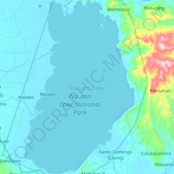
Name: Topografische Karte Naujan Lake, Höhe, Relief.
Ort: Naujan Lake, Malabo, Oriental Mindoro, Mimaropa, Philippines (13.10792 121.30381 13.23755 121.38926)
Durchschnittliche Höhe: 46 m
Minimale Höhe: -4 m
Maximale Höhe: 461 m
Vielen Dank für die Unterstützung dieser Website ❤️
Spenden
Spenden