
Spenden
Topografische Karte San Francisco
Klicken Sie auf die Karte, um die Höhe anzuzeigen.
Spenden
Über diese Karte
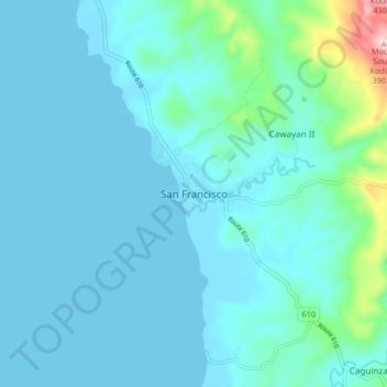
Name: Topografische Karte San Francisco, Höhe, Relief.
Ort: San Francisco, Quezon, Calabarzon, Philippines (13.30691 122.48007 13.38691 122.56007)
Durchschnittliche Höhe: 44 m
Minimale Höhe: 0 m
Maximale Höhe: 385 m
Spenden
Andere topografische Karten
Klicken Sie auf eine Karte, um ihre Topografie, ihre Höhe und ihr Relief anzuzeigen.
Sariaya
Sariaya is situated on a flat land except for a portion on the north occupying a part of the foot of Mount Banahaw. The municipality has the highest point of elevation on 3,800 feet above sea level at Barangays Concepcion Banahaw and Sampaloc Bogon.
Durchschnittliche Höhe: 117 m
Spenden
Spenden
Spenden
Spenden
Spenden
Spenden
Spenden
Spenden
Spenden
Spenden
Spenden
Laguna-Quezon Land Grant Lagoon
Philippines > Quezon > Real > Magsaysay > Maunlad
Durchschnittliche Höhe: 389 m
Spenden
Spenden
Sariaya
Sariaya is situated on a flat land except for a portion on the north occupying a part of the foot of Mount Banahaw. The municipality has the highest point of elevation on 3,800 feet (1,200 m) above sea level at Barangays Concepcion Banahaw and Sampaloc Bogon.
Durchschnittliche Höhe: 117 m
Spenden
Spenden
Spenden
Spenden
Spenden
Spenden