
Topografische Karte Waipukurau
Interaktive Karte
Klicken Sie auf die Karte, um die Höhe anzuzeigen.
Über diese Karte
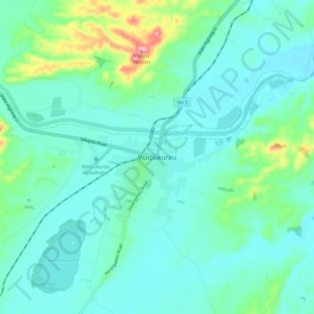
Name: Topografische Karte Waipukurau, Höhe, Relief.
Durchschnittliche Höhe: 153 m
Minimale Höhe: 118 m
Maximale Höhe: 305 m
Andere topografische Karten
Klicken Sie auf eine Karte, um ihre Topografie, ihre Höhe und ihr Relief anzuzeigen.
Waipawa Hill
New Zealand > Hawke's Bay > Central Hawke's Bay District
Waipawa Hill, Central Hawke's Bay District, Hawke's Bay, 4210, New Zealand
Durchschnittliche Höhe: 253 m
Kairakau Beach
New Zealand > Hawke's Bay > Central Hawke's Bay District
Kairakau Beach, Central Hawke's Bay District, Hawke's Bay, New Zealand
Durchschnittliche Höhe: 46 m
Otane
New Zealand > Hawke's Bay > Central Hawke's Bay District
Otane, Central Hawke's Bay District, Hawke's Bay, 4202, New Zealand
Durchschnittliche Höhe: 120 m
Ongaonga
New Zealand > Hawke's Bay > Central Hawke's Bay District
Ongaonga, Central Hawke's Bay District, Hawke's Bay, New Zealand
Durchschnittliche Höhe: 206 m