
Vielen Dank für die Unterstützung dieser Website ❤️
Spenden
Spenden
Topografische Karte John Gamble Park
Klicken Sie auf die Karte, um die Höhe anzuzeigen.
Vielen Dank für die Unterstützung dieser Website ❤️
Spenden
Spenden
Über diese Karte
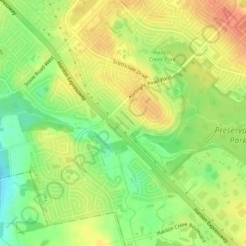
Name: Topografische Karte John Gamble Park, Höhe, Relief.
Ort: John Gamble Park, Hanlon Creek, Guelph, Ontario, Canada (43.50454 -80.23384 43.50709 -80.23042)
Durchschnittliche Höhe: 327 m
Minimale Höhe: 301 m
Maximale Höhe: 347 m
Vielen Dank für die Unterstützung dieser Website ❤️
Spenden
Spenden
Andere topografische Karten
Klicken Sie auf eine Karte, um ihre Topografie, ihre Höhe und ihr Relief anzuzeigen.
Guelph
This region of Ontario has cold winters and warm, humid summers, falling into the Köppen climate classification Dfb zone, with moderately high rainfall and snowfall. It is generally a couple of degrees cooler than lower elevation regions on the Great Lakes shorelines, especially so in winter, the exception…
Durchschnittliche Höhe: 344 m