Geolokalisieren
👉 Easily get elevation data in JSON, GeoTIFF and KML formats using Elevation API
Vielen Dank für die Unterstützung dieser Website ❤️
Spenden

Topografische Karte Tiqqi

Klicken Sie auf die Karte, um die Höhe anzuzeigen.

👉 Easily get elevation data in JSON, GeoTIFF and KML formats using Elevation API
Vielen Dank für die Unterstützung dieser Website ❤️
Spenden

Über diese Karte

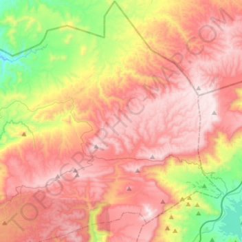
Name: Topografische Karte Tiqqi, Höhe, Relief.

Ort: Tiqqi, caïdat d'Imouzzer, cercle d'Agadir-Atlantique, Préfecture d'Agadir Ida-Outanane, Souss-Massa, Maroc (30.67008 -9.47777 30.88819 -9.22180)

Durchschnittliche Höhe: 1.231 m

Minimale Höhe: 552 m

Maximale Höhe: 1.779 m

👉 Easily get elevation data in JSON, GeoTIFF and KML formats using Elevation API
Vielen Dank für die Unterstützung dieser Website ❤️
Spenden

Andere topografische Karten

Klicken Sie auf eine Karte, um ihre Topografie, ihre Höhe und ihr Relief anzuzeigen.

Imi Ouaddar

Maroc > cercle d'Agadir-Atlantique > Tamri

Durchschnittliche Höhe: 56 m

Tizgui

Maroc > cercle d'Agadir-Atlantique

Durchschnittliche Höhe: 834 m

Tamraght

Maroc > cercle d'Agadir-Atlantique > Aourir

Durchschnittliche Höhe: 55 m

Tahanoute

Maroc > cercle d'Agadir-Atlantique > Aourir

Durchschnittliche Höhe: 287 m

Vielen Dank für die Unterstützung dieser Website ❤️
Spenden

Addar

Maroc > cercle d'Agadir-Atlantique > Taghazout

Durchschnittliche Höhe: 226 m

Alma

Maroc > cercle d'Agadir-Atlantique > Aourir

Durchschnittliche Höhe: 393 m

Tidili

Maroc > cercle d'Agadir-Atlantique

Durchschnittliche Höhe: 999 m

Mahmoud

Maroc > cercle d'Agadir-Atlantique > Tamri

Durchschnittliche Höhe: 151 m

Vielen Dank für die Unterstützung dieser Website ❤️
Spenden

Ifraden

Maroc > cercle d'Agadir-Atlantique > Taghazout

Durchschnittliche Höhe: 210 m

Imi Miki

Maroc > cercle d'Agadir-Atlantique > Aourir

Durchschnittliche Höhe: 161 m

Ait Bihi

Maroc > cercle d'Agadir-Atlantique > Taghazout

Durchschnittliche Höhe: 212 m