
Topografische Karte Danzé
Interaktive Karte
Klicken Sie auf die Karte, um die Höhe anzuzeigen.
Über diese Karte
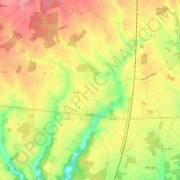
Name: Topografische Karte Danzé, Höhe, Relief.
Durchschnittliche Höhe: 151 m
Minimale Höhe: 101 m
Maximale Höhe: 190 m
Andere topografische Karten
Klicken Sie auf eine Karte, um ihre Topografie, ihre Höhe und ihr Relief anzuzeigen.
La Pente de l'Aigri
France > Centre-Val de Loire > Loir-et-Cher > Saint-Georges-sur-Cher
La Pente de l'Aigri, Saint-Georges-sur-Cher, Romorantin-Lanthenay, Loir-et-Cher, Centre-Val de Loire, Metropolitan France, 41400, France
Durchschnittliche Höhe: 99 m
Souvigny-en-Sologne
France > Centre-Val de Loire > Loir-et-Cher
Souvigny-en-Sologne, Romorantin-Lanthenay, Loir-et-Cher, Centre-Val de Loire, Metropolitan France, 41600, France
Durchschnittliche Höhe: 137 m
Conan
France > Centre-Val de Loire > Loir-et-Cher
Conan, Blois, Loir-et-Cher, Centre-Val de Loire, Metropolitan France, 41290, France
Durchschnittliche Höhe: 120 m
Ternay
France > Centre-Val de Loire > Loir-et-Cher
Ternay, Vendôme, Loir-et-Cher, Centre-Val de Loire, Metropolitan France, 41800, France
Durchschnittliche Höhe: 99 m
Lamotte-Beuvron
France > Centre-Val de Loire > Loir-et-Cher
Lamotte-Beuvron, Romorantin-Lanthenay, Loir-et-Cher, Centre-Val de Loire, Metropolitan France, 41600, France
Durchschnittliche Höhe: 125 m
Faubourg Saint-Lubin
France > Centre-Val de Loire > Loir-et-Cher > Vendôme
Faubourg Saint-Lubin, Vendôme-Quartiers Centre, Vendôme, Loir-et-Cher, Centre-Val de Loire, Metropolitan France, 41100, France
Durchschnittliche Höhe: 104 m
La Batardière
France > Centre-Val de Loire > Loir-et-Cher > Montrichard Val de Cher
La Batardière, Bourré, Montrichard Val de Cher, Romorantin-Lanthenay, Loir-et-Cher, Centre-Val de Loire, Metropolitan France, 41400, France
Durchschnittliche Höhe: 99 m
Bourré
France > Centre-Val de Loire > Loir-et-Cher > Montrichard Val de Cher
Bourré, Montrichard Val de Cher, Romorantin-Lanthenay, Loir-et-Cher, Centre-Val de Loire, Metropolitan France, 41400, France
Durchschnittliche Höhe: 108 m
Crouy-sur-Cosson
France > Centre-Val de Loire > Loir-et-Cher
Crouy-sur-Cosson, Blois, Loir-et-Cher, Centre-Val de Loire, Metropolitan France, 41220, France
Durchschnittliche Höhe: 96 m
Chouzy
France > Centre-Val de Loire > Loir-et-Cher > La Chapelle-Saint-Martin-en-Plaine
Chouzy, La Chapelle-Saint-Martin-en-Plaine, Blois, Loir-et-Cher, Centre-Val de Loire, Metropolitan France, 41500, France
Durchschnittliche Höhe: 115 m
Vouzon
France > Centre-Val de Loire > Loir-et-Cher
Vouzon, Romorantin-Lanthenay, Loir-et-Cher, Centre-Val de Loire, Metropolitan France, 41600, France
Durchschnittliche Höhe: 126 m
Le Bourg
France > Centre-Val de Loire > Loir-et-Cher > Chaumont-sur-Tharonne
Le Bourg, Chaumont-sur-Tharonne, Romorantin-Lanthenay, Loir-et-Cher, Centre-Val de Loire, Metropolitan France, 41600, France
Durchschnittliche Höhe: 122 m
Morée
France > Centre-Val de Loire > Loir-et-Cher
Morée, Vendôme, Loir-et-Cher, Centre-Val de Loire, Metropolitan France, 41160, France
Durchschnittliche Höhe: 126 m
Couëtron-au-Perche
France > Centre-Val de Loire > Loir-et-Cher
Couëtron-au-Perche, Vendôme, Loir-et-Cher, Centre-Val de Loire, Metropolitan France, 41170, France
Durchschnittliche Höhe: 176 m
Blois
France > Centre-Val de Loire > Loir-et-Cher
Blois, Loir-et-Cher, Centre-Val de Loire, Metropolitan France, 41000, France
Durchschnittliche Höhe: 95 m