
Topografische Karte Begaljica
Interaktive Karte
Klicken Sie auf die Karte, um die Höhe anzuzeigen.
Über diese Karte
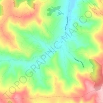
Name: Topografische Karte Begaljica, Höhe, Relief.
Durchschnittliche Höhe: 182 m
Minimale Höhe: 93 m
Maximale Höhe: 290 m
The village is located at the water source of the Begaljica river. The houses are located in the valley sides and flat areas nearer the river, while a large part is located on the hill as well. The highest elevations are at Gornji Kraj and Brđani. The atar (cadastral area) is large, while half of it is located in Šumadija, south of the Belgrade boundaries. The village is of the scattered type (sela razbijenog tipa), divided into the following parts: Gornji Kraj, Brđani, Topciski Kraj, Tašin Kraj, Prnjavor, Nestorovića, Radosavljevića, and Palalića Kraj. The central part is not divided into parts. Prnjavor (also known as Šatorište) is located by the Rajinovica Monastery. There is a total of 200 houses, and they are located equally distanced from each other in all parts.