
Topografische Karte Millwood
Klicken Sie auf die Karte, um die Höhe anzuzeigen.
Über diese Karte
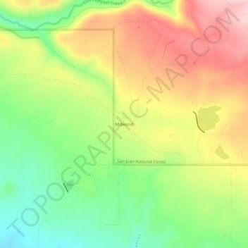
Name: Topografische Karte Millwood, Höhe, Relief.
Ort: Millwood, Montezuma County, Colorado, United States (37.40166 -108.35370 37.44166 -108.31370)
Durchschnittliche Höhe: 2.320 m
Minimale Höhe: 2.216 m
Maximale Höhe: 2.434 m
Andere topografische Karten
Klicken Sie auf eine Karte, um ihre Topografie, ihre Höhe und ihr Relief anzuzeigen.
Mancos
United States > Colorado > Montezuma County
According to the United States Census Bureau, Mancos has a total area of 0.6 square miles (1.6 km2), all of it recorded as land. The town is located in the Mancos River valley at an elevation of approximately 7,000 feet (2,100 m). The Mancos River was named by Spanish explorers (Rio de los Mancos - "River of…
Durchschnittliche Höhe: 2.158 m